Saturday, May 31, 2014

The Moose Are Loose in the Palouse

We left Pendleton several days ago headed to Spokane via Highways 11, 12, 127, and 195. The roads ran out through rolling hills, often covered in wheat or barley.

Didn't see any farm equipment in action. This was the only combine we spotted that wasn't on a farm equipment dealer's lot. I'm pretty sure they're not planning to use this one this year!

I loved all the small towns with the highway serving as the main street. Most of the towns seemed to have lots of life left in them with very few empty store fronts.

Lots of grain elevators along the way. This one wasn't so dusty as it was in need of paint.

I couldn't resist noting that there's always an outlier. White house, white fence, and three white vehicles. I guess the silver one is owned by the black sheep in the family??

And, of course, no day is complete without a barn picture. It's not too late for this one. I'd sure like to know what caused this unusual damage.

We were really surprised to see two moose running up the hillside north of Colfax. The picture is lousy and I only got one of them, but... I was really surprised to see a third moose east of Coeur d'Alene the next day but couldn't get a picture of it, either. That's more moose than we saw in Alaska last summer.

Home for the past three days was the Alderwood RV Resort in Mead, just north of Spokane. We stayed here a couple years ago as well. It gets scored low for site width for beasts with large slides, but works very well for us. The weather has been cool enough that we really didn't need the hook-ups for the air conditioner.

Friday, May 30, 2014

More Research (or Nightmares)

While we were in Alaska last year, I heard several people singing the praises of a Ram dealer in Kellogg, Idaho. Since it was relatively close, I went over there yesterday to do some reseach.

Turns out, they're the world's largest Ram dealer

and have several GM brands including Chevy & GMC trucks right across the street. I discovered as I was leaving town that they have lots all over town full of new trucks. The consultant I talked to said they only sell about 300 GM trucks a month, and many more RAM trucks.

Unfortunately, I have some clearance issues. The bottom of the Scamp is about 56 inches. That's with a 1.5" lift already in place. I could add another 2.5 inches of lift under the frame, but then the trailer won't fit in the garage.

The GMC 1/2 ton trucks on the lot were just over 54" high. The Ram 1/2 trucks were an inch higher, and 3/4 trucks were yet another inch higher. That's a long ways from the 46 1/2" bed rail height on the Tacoma.  Maybe a flat bed is the answer, or just keep the Tacoma...

Thursday, May 29, 2014

What If?

We love our Scamp and it has done very well for us. It fits the Tacoma, and it fits comfortably into boondocking spots. Even so, there have been some "what if" thoughts wandering around in my head. The Tacoma is approaching 240,000 miles so I'm thinking about potential replacements. But should a replacement be Scamp sized, or should it be more capable?

Since we were "just down the road" from La Grande, where Northwood builds the Arctic Fox and Fox Mountain 5th wheel trailers, we headed there to get a brochure and specs list. How capable should a new truck be - just in case?

The area around the factory was parked full of rigs, from pickup campers to large 5th wheels and everything in between. If we ever replaced the Scamp it would have to be a true 4 season unit, be no more than 30' long, and be capable of boondocking.

A review of the specs indicated that all of these units would require at least a 3/4 ton pickup, so if we were serious about a future trailer upgrade, we shouldn't be looking at 1/2 ton pickups as a Tacoma replacement. On the other hand, if we stay with the Scamp, a new Tacoma could be a logical choice.

More research to come.

Wednesday, May 28, 2014

Pendleton Woolen Mills

I intentionally scheduled some time in Pendleton on our way through because I wanted to stop (again) at the Pendleton Woolen Mills. I think the first visit may have been before BJ and I were married and we don't have enough fingers and toes together to count that high.

But this visit, I'm going to blame on my river friend, Greg, who used Pendleton blankets instead of a sleeping bag on our Grand Canyon / Colorado River trip this past March. By the way, my Facebook friends know this, but Greg wrote three wonderful blog posts for the Pendleton blog about our trip. You can access them here (1st), here (2nd), and here (3rd).

I stopped by the shirt racks for a moment while BJ headed to the ladies side of the store,

but our real target was blankets. We started in the Outlet shop (behind the retail shop) where we were fortunate to find it was old folks Tuesday. Actually, I believe they called it Senior Discount Tuesday, but you get the idea. We looked at the National Park series, but keep gravitating towards the Jacquard blankets with Native American motifs.

We ended up with a Chief Joseph in forest green and one from the Eddie Bauer collection that I couldn't find on their website. Lots of fun, and no, I'm not planning to take these on river trips.

Since we were there at the right time, we even did the mill tour. Noisy, but interesting. All the way from carding the wool to making the yard to weaving the fabric and inspecting it. The battery in the camera died, so this one is a cell phone photo.

It's a great stop if you're in NE Oregon. You can do the same at their Washougal Mill in Washougal, WA if you're in the Portland area.

Tuesday, May 27, 2014

Highway 395


Lots of RV folks have spend time on Highway 395 in California, traveling the east side of the Sierras. In spite of a lot of time in Oregon over the years, I'd never spent any time on Highway 395 in Oregon. We picked it up in Burns yesterday and followed it north to Pendleton. We'd been running in high desert but started making a transition in Burns.

It wasn't long before we started getting into timber. Initially some fine looking Ponderosa Pine and later some Douglas Fir of marketable size.

There were meadows full of flowers north of the middle fork of the John Day river

and miles of grassland as we got closer to Pendleton.

Along the route there were lots of buildings that were starting to show their age.

Some may still be used

while others were in various stages of decay.


The community church in Fox needed paint and broken windows replaced. It looked like it wasn't being used but the sign on the front looked fairly new.

We saw antelope, cattle, and sheep in various places along the way. Some of the cattle were bunched near the road as if they expected a friend to stop by.

It was pretty clear that some folks weren't as accepting of drop-in visitors!

Home for a couple nights is the Wildhorse Resort operated by the Wildhorse Casino near Pendleton. Full hook-up sites (30 amp) for $25 per night. Three bars of Verizon 4G without the antenna or amplifier.

Monday, May 26, 2014

Share the Experience

We interrupt this programming for a public service announcement:


About a month ago, CozybeGone, an Internet friend, mentioned a photo contest. I'm not much of a contest guy but I did follow her link to discover the National Park Foundation was sponsoring the Official Federal Lands 2014 Photo Contest. The winning photo must be taken on federal land (or water) and will be used to illustrate the 2016 Annual Federal Recreational Lands Pass. There are already over 4600 photos entered so it is an extreme long shot, but I've thrown a handful in the pot. You can only enter two photos each week but the contest runs until the end of the calendar year.

2014 Annual Pass from Recreation.gov
You can see the photos I've entered at this link.

I know that there are a bunch of you out there that are much better photographers than I. I'd encourage you to take part - I'd love to say I know the person that took the picture on the 2016 Annual Pass.


We now return to our regularly scheduled programming:

Sunday, May 25, 2014

Home for the Holidays

With the Page Springs BLM campground full by noon on Friday, we continued north from Frenchglen on Oregon 202, looking for a likely boondocking spot. Everything on the east side of the road was Malheur National Wildlife Refuge and posted No Camping at each road. We spotted a potential spot with a sheltering bluff on the north side about 12.5 miles north of Frenchglen but it was visible from the highway.

A flyover with Google Maps led us to check out Jack Mountain Road about 24 miles north of Frenchglen. We ended up with a spot with a bluff (and power lines) to our west, and out of sight of the highway. According to the US Public Lands app that Chris and Cherie of Technomadia developed, it's on the BLM side of the line, but just barely.

While we're not protected from the north wind and resulting dust that sprung up in the afternoon, we do have a view of the Wildlife Refuge in the distance.

The wind settled down before sunset with the remaining haze making for a colorful sunset.

It rained for a little while Friday evening which cleared the air and perked up a few of the flowers.

The phones are showing 0 bars of Verizon 3G, but we're getting 3 bars of 4G data using the antenna and amplifier. We'll call this home until Monday morning when we'll continue our trek to the north.

Saturday, May 24, 2014

That's Not Nice - Or Is It?

We departed Winnemucca yesterday morning on our continued quest for lonely roads and a place to nest for the holiday weekend. We started out heading north on Highway 95 and then turned off onto Nevada 140. We picked up four large buses a few miles outside of Winnemucca and they were content to trail us all the way to the state line. With that exception, we didn't see more than vehicles all the way to the Nevada border.

Microsoft Streets & Trips said there was gas at Denio, Nevada but not so. On the other hand, there was gas and diesel at the general store in Fields, Oregon that it didn't know about. The buses all followed us to the store where they each bought $20 of diesel. Something about needing to travel out of Nevada regularly to keep their interstate permits & Fields was the closest place to get a fuel receipt as proof they were out of state. With receipt in hand, they headed back to Winnemucca where they make their living hauling miners to the mines.

We stopped at Long Hollow Summit on Oregon 202 to let the dog go for a walk. Lots of cow & calf pairs in the area

on both sides of the fence. Loved the gabion fence posts at the gates and corners.

If anything, Oregon 202 was even less used than Nevada 140, at least until we got close to Frenchglen. The very steep descent into Frenchglen that the Allstays Camp and RV app told us about was everything they'd said. Glad it wasn't longer and that I used first gear coming down the hill.
In addition to this derelict cabin, there were several scattered, active cattle operations along the way, including one with a long, asphalt, private airstrip.

Our anticipated destination was the Page Springs BLM  first-come first-served campground southeast of Frenchglen. Unfortunately, every one of the nearly 35 sites appeared to be "taken." About half featured a folding chair, a bucket, an open ice chest, or some other singular item (and a paid tag) giving the distinct impression the spaces were prepaid and saved for friends yet to arrive. I didn't think it was very nice, but I suppose the friends that benefited thought the system was wonderful!

Friday, May 23, 2014

Technological Changes

We hadn't been on the road too long yesterday morning when we spotted this sign about the town of Austin, Nevada. I would have shown you a picture of the town, but I was too busy looking for the gas station to take a picture. One thing about lonely roads is that you don't pass up gas stations.

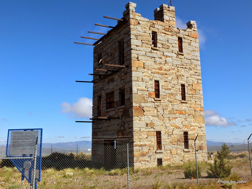
Just around the corner Not far from the gas station was the Stokes Castle. Built in the fall of 1896 and the spring of 1897 by a tycoon as a summer residence for his sons, it was lived in for a couple months. It's visible if approaching Austin from the west, but it took a book for us to find it when approaching from the east.

There were also ruins of a large mill visible below the road to the Castle. The town had lots of period buildings and homes. It really deserved much more time that the 15 minutes we gave it. It's a place that could serve as a base for days of back country exploration.

On the west end of town was one of the few remaining "Loneliest Road" signs. Meant by the author of the Life Magazine article in 1986 as a slam, the State of Nevada took pride in the slogan and made special signs that became collector's items.

This section of Highway 50 ran adjacent to and sometimes overlapping the routes of the Overland Mail & Stage coaches, the Pony Express, and the Overland Telegraph - Pacific Telegraph systems. In each case the remains near the highway have been enclosed in tall chain link fencing. This is the remains of the New Pass Overland Mail & Stage station

At Rock Springs there was a convergence of technologies. On the west side of the highway were the remains of the stage coach station while about 1/4 mile away across the highway were the remains of a Pony Express station which had taken mail business from the stagecoaches. Just north of the stagecoach station were these remains of a telegraph repeater station which put the Pony Express out of business.

Having nothing to do with technology but weird enough to cause us to stop was this shoe tree. It's not clear what started it, but this cottonwood tree is festooned with hundred of pairs of shoes.

Here's a close-up of just one small section of the tree. We likely wouldn't have even noticed this weirdness if it hadn't been for the mention in "Traveling America's Loneliest Road" by Tingley and Pizarro. This book was the key to seeing the sights along Highway 50 and was recommended to us by a State Park Ranger.

About 9 miles off the highway (4 miles of relatively good dirt on an unmarked road) was this granite sign looking much like a verbose headstone. This was ground zero for an underground nuclear test in 1963. The site is near Fallon Naval Air Station's bombing range.

Home for the night was the popular Walmart in Winnemucca. I-80 west of here gets the prize for the boringest road in America!

We anticipate spending the weekend near Steens Mountain in Oregon but may be out of cell coverage.