Monday, August 31, 2015

She Said, "Don't Do It"


and that was enough temptation for me. The gal at the Los Alamos Information Center told me all about the Jemez Mountain National Scenic Byway but also said not to tow a trailer over the hill towards Chaco, so....

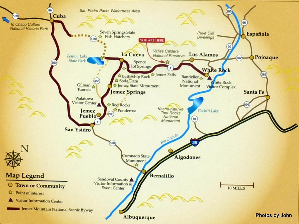
I had to go check for myself. The whole idea of the scenic route sounded right up my alley. The plan for the day was to go from Los Alamos (right center), across the top to Cuba (top left), then in order to get back to the trailer again, go down to San Ysidro, up through Jemez Springs, and back to Los Alamos.

It started with this. Actually, it didn't. The first couple were 10 mph but I was too busy to take a picture.

I passed through a section of Bandelier National Monument before arriving at the first views of a huge, wide open, grassy valley. This valley is a caldera, formed when the land subsided after a massive volcanic eruption. I was taken with the expanse - nearly 90,000 acres that was once the Baca Ranch.

I'd heard about the Valles Caldera National Preserve in Los Alamos. It's in the process of becoming a national park and there have been a lot of public input meetings in the area. It wasn't my destination for the day, but the gate was open so...

There are only 12 "walk-in" backcountry vehicle permits available per day. I didn't expect to go beyond the Visitor Center but, by 10:30 I have one of the last coveted (free) permits in hand. I'm only 20 miles into my planned trip, and now I'm off on a serendipitous wild goose chase.

The historic ranch headquarters are located about a mile past the Visitor Center. There are several homes of various ages in the area

including some really cool log homes with big porches. I was started to feel heart palpitations trying to avoid covetousness.

The open roads in the area were gravel. They'd be considered good logging roads when I grew up. I must admit, I was starting to wish I had a good 12v. air compressor so that I could drop the air pressure in the tires until I was ready to tow again. I know they had a nice road grader because I saw it hiding behind the houses, but I don't think they use it.
As I got up towards the north end of the road I noticed a few people out fishing in the meadow.
Turns out the headwaters of the San Antonio creek are world class trout fishery. You have to have a New Mexico license, plus a day use road permit, plus a special fishing permit, but obviously people were finding it worthwhile. I must admit, it was a pretty beautiful place to be, fishing or no fishing.

I headed back because the clouds were building and I still have lots of miles to go if I was going to finish my prove she's wrong research trip.


As I continued southwest on Highway 4 I noticed the snow plow sign and immediately beyond it saw a group of young teens learning to rock climb - in shorts. Somehow, these two don't seem to go together.


I'd heard there was some road construction but the surface had been beautiful, new asphalt. So new, it didn't have any lane markings yet. I got stopped at the head of the line where they were loading dump trucks full of gravel. Once the Follow Me truck arrived and we got a little ways down the road, I saw the construction - They're putting down a seal coat of gravel over the brand new asphalt. They do it differently here.


Shortly after I turned west on Highway 126 I saw the Caution sign. Is an RV trailer a "House Trailer?" Does this mean I couldn't do what I was hoping to do? Shortly after passing the entrance to Fenton Lake State Park, the asphalt ended

and the road became truly one lane in a few places, rutted and potentially very soft when wet in places, but all told, a decent forest road.

Eventually, I got to one of my goals for the day. I've always wanted to go to Cuba, and now I can say I did. Didn't see any of those late 1950's Chevys running around, but clearly it was Cuba! There's a road that leaves from here heading west to Chaco Canyon but time is fleeting, and I still need to get back to my trailer on the mountain above Los Alamos.

Apparently, when I started north through San Ysidro, I was getting into the heart of the Scenic Byway. There were neat adobe style houses but the church was the only picture-on-the-fly that was reasonably in focus.

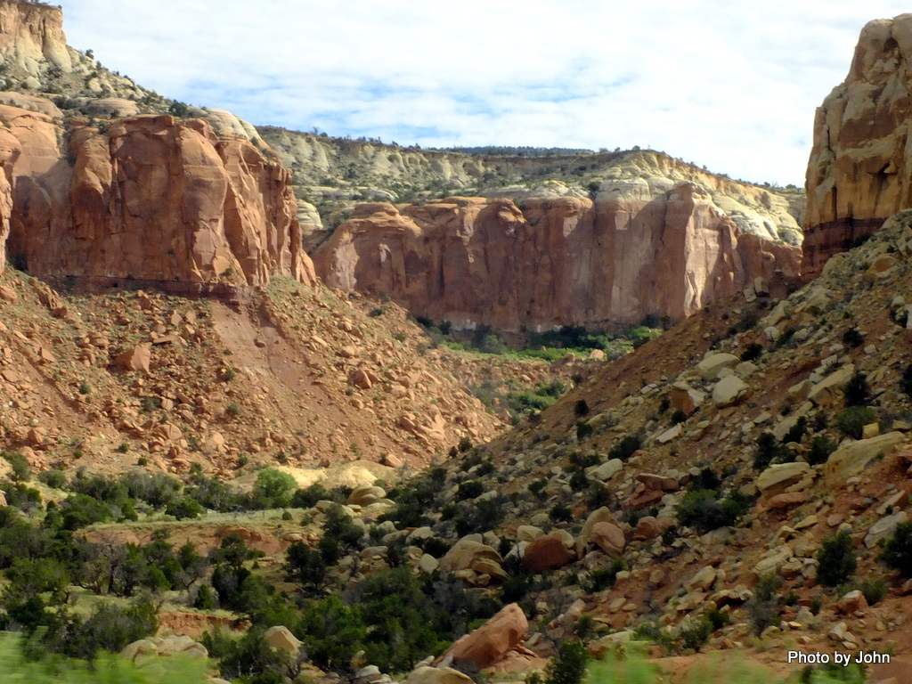
The mountains were beautiful, but the light in the narrow canyon was disappearing. There were supposed to be hot springs, and waterfalls, and old pueblos, and places to spend time gazing in wonder, but...

Slowly cruising through the town of Jemez Springs, I happened to get a picture that included the Los Ojos Restaurant and Saloon. Apparently it's been voted "most authentic," whatever that means.

I'd been pushing because I wanted to see the remains of Giusewa that was built about the time the Pilgrims were arriving at Plymouth. Wouldn't you know it, they were turning off the lights and putting up the closed sign as I drove up, so all I got was this picture. It did intrigue me how much the structure blended into the land.

Soda Dam became my last stop of the day. There just wasn't enough light left.

What was learned is this route would be ideal for a BMW motorcycle although I didn't see any motorcycles during the day. I also learned that the hairpin turns combined with the grades and altitude was really going to put the squeeze on the Taco's towing abilities.

200 miles, well over 8 hours, and the end result is that you can't get there from here, at least not traveling the way I'm traveling. The Jemez Mountains deserve at least a week of exploration alone.

Chaco is going back on the "gotta do it sometime" list. And I'm going to have to say she was right. I think that's the second time that's happened in a couple months. I hope it's not turning into a habit. ;-)

Saturday, August 29, 2015

Take a Hike!

I stopped by the Information Center at the Chamber of Commerce with some questions. They weren't hitting on all cylinders, but they were quick with a map and information about the wide variety of trails in the area. Unlike some friends who have been specializing in trails with verticality around Ouray, Colorado, I was looking for something easier. Kwange Mesa Trail it would be.

Of course, I didn't read all the info - I just looked at the map and decided I'd go out on the old road, and come back on the trail. For some reason, their on-line info has it marked the other way.

Turns out the old road may have been related to an underground gas line that runs down the mesa and off the end.

I have no idea what the flowers were, but I sure like them. They were growing like weeds on the roadway on the way out.

As I got out towards the end of the top level of the mesa, I started noticing that the trail had be worn into the volcanic rock. At the end of the top level, a very clear (much clearer than in the picture) worn trail descended to the next level down.

In spots, individual steps had been cut and or worn in the rocks. Clearly, this trail was here long before Los Alamos became the Secret City.

I had to decide if I wanted to descend to a third layer where I could perceive a route, but it didn't feature the worn trail to give me confidence.

I was glad I was wearing my hiking boots and that I'd done some rock climbing as a kid. I did manage to find the cache that was tempting me. It's only been found six times in the last two years - no wonder it was rated the way it was.

It wasn't a free find. On my way back up to the second level, my faithful, ever ready Nalgene bottle came out of my fanny pack and bounced down the cliff. :-(

The route from the second level back up to the top was very clear on the return.

The trail back wandered through grass and trees, while my mind wondered why the end of this mesa wasn't built out with housing like the mesas to the north and the south.

The trail proved to be a good test of the ankle that I twisted while I was at Animas Forks. It's finally no longer sore no matter how much I push it. About 5 miles all told with 6 lonely caches = lots of fun!

Thursday, August 27, 2015

Propaganda or Education?

One of the more recognizable buildings in downtown Los Alamos is constructed with vertical walls logs. It was originally built as the main building of the Los Alamos Boys Ranch. The Boys Ranch was created in the 1920's after the original homesteader proved up and sold out.

The historical museum is housed in one of the houses on Bathtub Row, houses that were built for the teachers at the Boys Ranch. The museum does a very good job in compact space to share about the original timber operations, homesteaders, and school prior to the government requisition of the area for the Manhattan Project.

Most of their displays didn't lend themselves to photography. This area represents the living and dining area in one of the better homes during the war years. I suspect the window air conditioner was a later acquisition!

Conversely, the Bradbury Science Museum was large, relatively new, government funded, and fully of bright displays and an excellent movie about the wartime operations in Los Alamos that limited the bombs effect to about 2 seconds of mushroom cloud footage.

I really did like the life sized, highly detailed statues of Major General Leslie Groves of the US Army Corp of Engineers (who built the Pentagon) and Dr. J. Robert Oppenheimer. There was a section of the museum that provided vignettes of lots of the people who lived and worked at Los Alamos, but the museum ignored the tension between the General and the "prima donna" civilian scientists who, in his mind, were taking advantage of the military resources to, for example, have their babies in the hospital where they got free care.

Much of the museum space was taken up with colorful displays about a wide variety of subjects such as the use of algae as a fuel source. Based on what was seen here, you were left with the impression that the Los Alamos National Laboratory was nearly the sole source of knowledge on this subject, something Arizona State University at the Polytechnic Campus would find offensive.

Over in one corner was a large panel, perhaps 6 feet wide by 8 feet tall justifying the use of the bomb, "Atom Bomb Saved Civilians and Military Lives." The display was funded by the Los Alamos Education Group, a coalition of Navajo Code Talkers, Bataan Death March Organization, Veterans of Foreign Wars, American Legion, and Laboratory Retiree Group.

On the facing wall was the opposing viewpoint on a poster that might have been 4 foot square. It included quotes from Admiral William Leahy, General Douglas MacArthur, and General Dwight D. Eisenhower all saying use of the bomb was not necessary. The most interesting thing on the poster was the text of a telegram from the Emperor of Japan requesting a peace treaty over three weeks before the first bomb was dropped on Hiroshima.


Over in one corner was an example of the Little Boy (Uranium-235 dropped on Hiroshima) and Fat Man (Plutonium-239 dropped on Nagasaki) bombs.

Throughout the museum, even on museum descriptive placards, there was a dissonance of dates and other information.

I am impressed with the civil, industrial, and human resources that made this happen, but it's still not clear to me that the use was necessary. Meanwhile, the museum does a great job of making it all seem nice and tidy.


Tuesday, August 25, 2015

Hiding in the Secret City

With a clue from Campendium, I found a different spot on Forest Service land about 700' above town to call home for the next week or so. I knew I wanted to visit the History and the Science Museums while I'm here, but I've discovered the area is riddled with trails, so I suspect there will be some hiking as well.

I guess if I can see them, maybe they can see me too? This spot has a lot to make it special. It's only about 100 yards from a hard surface road, but very nearly out of sight from the road. There are only two or three cars that drive past on the gravel road each day, and there isn't any room for other rigs within view. The effort to get here likely precludes a lot of people from trying.

Of course, it did take a bit of extra effort to get the rig leveled, and anything much bigger might have a challenge getting turned around, but the view and relatively easy access to town is worth it.

Even at night, the view is pretty special.  The dead tree shows up even more at night!

I discovered there was a practical reason for the escape hatch in the roof. It's for taking pictures without the window screen in the way!
The place isn't so secret anymore - not when you label the water tower!

But it still has some strange vibes to it. In some ways it reminds me of a college town, but then there are the reminds that things could be different. I pass through this gate with the grass growing up around it on the way to camp from town. It closes off access to the only road west.

I've seen these signs in several places, but have aways been reluctant to stop and take a careful picture.

In spite of the signs, you don't see obvious signs of security in the community. I suppose that could change at a moment's notice. I did have a city police pickup drive slowly past my camp one evening, but then the road precludes driving fast.

Sunday, August 23, 2015

Looking for the Secret City

I left Heron Lake State Park behind with a destination in my head. For interesting stuff in between, I depended on geocaching names that caught my attention.

Even in Arizona, shrines are much rarer than here. This one has a number of crosses around it with various people's names who have passed.

Just down the way I spotted a Continental Divide Trail marker, but nothing around it to suggest where the trail actually was. Apparently, not too many people have come this way - or perhaps the road is the trail?

I didn't pay much attention in class, but when I started seeing mention of Georgia O'Keeffe, I knew I should know about her. This country was her subject. It reminded me somewhat of Sedona but on a much grander scale.

It even looked good in the rear view mirror.

It may be a product of where I was raised or where we've traveled, but I don't think I've stayed in a Corp of Engineers campground more than once. When I spotted Abiquiu Lake, I had to check it out. The reservoir was low, but it still looked nice. $8 for the senior discount for a site with power & water looked even better, but they were full and I had other places to go.

The country continued to have beautiful greens and reds, and the road kept going up and down, and up and down through small towns.

With Kate (I switched to the British voice on the Garmin) convincing me to make the correct turns, I finally found the secret city. Most of it isn't so secret any more, but there are still lots of gates and guards around the place.

The town is built on a series of mesas so it's either up or down no matter where you go. I'm sure I'll find somewhere to stay.