Showing posts with label Petroglyphs. Show all posts

Sunday, September 6, 2015

Petrified!

For early readers, you caught me! I'd dropped the pictures in when I got home from my month in Colorado and New Mexico, but never wrote the text.  Sorry!

I worked my way west from my last camp in New Mexico, watching the elevation decrease and the temperatures increase.

With a short day, I toured through Petrified Forest National Park. I appreciated some of the historic buildings, especially this one that had a beautiful view of the Painted Desert. I love adobe buildings and this one was spectacular.

This row of old telephone poles (sans wire) paralleled Route 66. Once the freeway was built (you can see trucks in the background) the road surface of Route 66 through the National Park was removed, but you can still see the roadbed in places.

They had some rust to commemorate Route 66. The road through the park winds for miles with pull-outs for areas of interest.

There were lots of foreign visitors the day I was there. These folks were from Spain and Italy, all riding motorcycles. The telescopes are for viewing Newspaper Rock below this viewpoint. The rock itself is now off limits.

It was nice to have a long telephoto lens to be able to pick up some of the petroglyphs. I especially liked the hand at the right edge of the rock.

I couldn't get a good angle on the Agate Bridge. It's a petrified log that was braced by a concrete beam in the 1920s. I'd driven through the park once before but didn't remember this feature at all.

In the southern section of the park, the petrified logs were everywhere. It's like somebody did a bunch of logging but the logs petrified before they could get them yarded and loaded.

Even though it was mid-August, and very hot, there were still some flowers blooming.

Some of the logs looked like they'd been bucked into short pieces before they petrified. Some of them had rotted out cores.

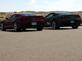
I couldn't resist. A pair of matching (except for color) Corvettes. His and Hers on a road trip from the mid-west. I guess that's one way to resolve who gets to drive. Or maybe it was the solution to luggage space. I didn't ask them.

Home for the night was Homolovi State Park because they have 30 amp electric sites for $25 plus the reservation fee. Turns out, there were only six of us in a campground with nearly 150 sites, so reservations were certainly unnecessary, at least in mid August!

Thursday, May 21, 2015

Last of the ‘Glyphs

April 26 -- I stopped at Snow Canyon in part because I didn’t have a Plan D boondock selected and I didn’t really want to head for one of the Lake Mead options. The other reason was that I thought I’d seen a petroglyph picture associated with Snow Canyon.

Turns out, there are a couple ‘glyphs at one of the campsites, but that site was occupied. The super nice gal at the desk pointed me to the Anasazi Valley trailhead between the communities of Ivins and Kayenta. It’s an area within the Santa Clara River Reserve and has a bunch of petroglyphs. It’s supposed to be 2.5 miles r/t but didn’t seem like it.

Not only were the designs different, but the position of the petroglyphs was different as well. Many of these were done on the top of the rock, exposed to the elements. Even with that, and a large number of people visiting each day, they remain in amazing shape.

Instead of rock art on a large cliff panel, these were all on boulders and broken blocks of rock.

Those that were on the vertical or near vertical face of the rocks were all within arm’s reach.

This was the only group I spotted that were large animals. The two big ones were perhaps 2 feet high, each.


Part of what intrigues me about rock art is that no one can be positive about what it means, but several sources suggest the spiral pattern is a sign to tell others that the migration continues. With that, I’m not anticipating any more petroglyphs on this trip while my migration continues home. 

Monday, May 11, 2015

More Than Fruit in Fruita

April 21 -- Fruita, Utah is known for its fruit trees and Capital Reef National Park

as well as it's beautiful cliffs.

Those cliffs provided the place for lots of petroglyphs. A major portion of this panel was destroyed in 1952 when the large portion in the center fell away.

There are some figures that remain to the left side of the spalled area as well as these animals right at the center point.

To the right side of the now missing section is a number of small figures,

and then a group of larger figures that reminds me of the sort of thing you see on the back window of some family vehicles. This panel is attributed to the Hisatsinom, or People of Long Ago, sometimes called the Fremont culture.

As with many panels, when you look around, you find other images in the same general area. This cliff is clearly somewhat active - there were lots of places with just a partial image remaining and a chunk of rock gone from the cliff face.

Home for the night was the Sand Creek RV Park in Torrey, Utah. Their laundry was the primary attraction, but strong wifi, and a chance to drain tanks were important considerations as well.

Tuesday, May 5, 2015

More Nosing Around

April 18 - I was getting a bit smarter – I stayed at the trailer until mid-morning when the temperature climbed into the 50’s. I’d planned to visit more ruins in the Butler Wash area but there were already 5 cars at the trailhead so I kept going.

I went for a hike, looking for a petroglyph panel that I’d heard about, (without success), but I did spot some interesting water or wind-worn rock

and a survey marker on a pipe with a 1919 date that I digitally enhanced to hide the township and range numbers.

Not so terribly far from there, I was able to spot a set of ruins in another draw. They certainly looked impressive from a distance,

and even more so, up close. Two of the structures still have roof beams in place.

It was a delight to be able to get close enough to see the detail of the construction around the upper window. A stone sill with multiple branches to form the lintel – that seems reversed to my mind, but it has certainly stood the test of time.

There were a few petroglyphs in the alcove,

most of them quite faint.

In fact, these above the metate grooves, were only given away by the visible texture.

I was delighted to see a few handprint pictographs – the first that I’ve found on this trip.

All of this exploration was made much easier with a quality topo map from amTopo. This visit, in addition to the previous three posts, as well as the post from April 17th, were all done while boondocking at Comb Wash.

It's time to head west, looking for bridges and more pictographs.

This post was uploaded and scheduled on wifi from my site at Sand Creek RV Park in Torrey, Utah.

Monday, April 27, 2015

Edge of the Cedars State Park Museum

April 15th -- I stopped by the Edge of the Cedars State Park Museum in Blanding. It’s another place we’ve bypassed for years as we hurry to Moab for our Green River trips. The Museum (and Repository) are built immediately adjacent to an archeological site.

I was very impressed with some of the pots that were on display in glass cases in the lobby. Not only did they have these incredible pots, they also had the stories of discovery by the people who found the pots.

Turns out, pots are a major component of their collection. They built a portion of their repository with glass walls so that even a portion of the stored collection can be viewed.

Throughout the building, the walls were painted with replicas of rock art. At the front desk, they loaned each visitor a book explaining the style and the assumed meaning of each panel.

On the second floor, in addition to more pottery, there was a collection of arrow heads,

and a series of photographs of rock art panels that had been taken expressly as documentation of these panels. The artistry of these panels was exquisite. They’d even tell you where they were located, if the name of the county and the state were enough information!

Outside, part of the site has been restored, resulting in a very nice interpretive ruin.

Although it is a State Park, it does not include any camping facility since it is located in a residential neighborhood. Don’t let that scare you off – the streets are very wide. The parking lot is striped primarily for autos, but they do provide some RV parking as well.


This post was uploaded and scheduled thanks to the Blanding Visitor Center on my 2nd visit!

Thursday, April 23, 2015

Wolfman Panel

April 14th -- I based at Sand Island BLM campground while I visited the Wolfman Panel and drove the Valley of the Gods road.

San Juan County road 262 heads north from Highway 163 about 1.8 miles west of the Sand Island road. It is gated (unlocked but close it behind you) and unmarked at the highway, but is exactly across the road from the marked entrance to the Bluff airport. BTW, the Trails Illustrated Grand Gulch Cedar Mesa Plateau map #706, updated in 2013 is incorrect. The airport entrance passes the marked drill hole headed to the southwest end of the airstrip.

I followed 262 west and then north for one mile to the cattle guard. This is the first cattle guard on the road so it’s really hard to miss. Turn left on the south side of the fence line and drive about 400 feet to a small parking lot. Kelsey’s book says 4WD can continue further, but the track beyond the first parking lot now has posts in the roadway.

There were a few cairns in place when I visited, but I initially chose to ignore them because I’d heard of ruins on the other side of the wash. As soon as I spotted the top of a potential alcove, I headed that way to spot the remains of some mud plastered walls

and a very nice structure tucked back into the deepest part of the alcove.

To get to the panel, I found the old cattle trail that heads south down the east wall of Butler Wash. Towards the top of the trail, a large rock now blocks the way. Skinny people may be able to go left. Published accounts suggest you can go right around the rock. I elected to go over it.

Once past the large rock, an alcove in the east wall is apparent. The famous Wolfman is on the dark varnished wall near the right edge of this picture.

The Wolfman petroglyph has been damaged by some thoughtless person who apparently mistook it for a target.

It was fun to study the wall a bit. In addition to the obvious Wolfman, there were lots of other interesting details.

In some ways, I liked the goose with a tiller on its dory, just left of the Wolfman. Given the time period when these petroglyphs were created, apparently the artist was thinking of something else or was a prophet.

There were other, much fainter petroglyphs closer to the alcove, although I didn’t notice them on my initial approach.

Of all of the images, I think this geometric design was my favorite. Once again, marked by target shooting. Of all the pictures I took of this, I liked this view up the wall the best, so that’s what you get.


Here’s the view of the stone blocking the trail from the lower end. The route around the outside looks workable in the picture, but I decided it was too much exposure for me. I went up and over on the way uphill as well.

This post was uploaded and scheduled on fast complementary wifi while I was eating dinner at the Twin Rocks Cafe in Bluff, Utah.