Showing posts with label Alaska. Show all posts

Thursday, June 20, 2019

Don't Be Chicken

All too many people say don't be stupid when talking about driving the Top of the World route between Dawson City, Yukon & Chicken, Alaska. My response is don't be chicken! Since the border is closed during the winter, the first step to this route (westbound) is the free seasonal George Black ferry to cross the Yukon River. We missed out six years ago because the river thawed later than normal

I checked the weather report a couple days prior and it was calling for low 70's and sun. We did start out the day with some bright spots but very little true blue sky. At least it was clear enough to understand where the "Top of the World" name comes from.

The vast majority (all but a couple miles) from Dawson to the border (67 miles) was wide, excellent gravel. I didn't drive the posted speed limit (50 mph equivalent) but was very comfortable driving at 40 to 45 mph on this section. The views were beautiful and the road was excellent. We had occasional sprinkles, just enough to hold the dust down.

The Canadian and US border post was visible when we came around a corner.

Customs questions were of the typical firearms, alcohol, fresh fruit variety. Less than five minutes and we were on our way. The more interesting part of the border crossing was the cabin across the road from the sentry station. Not clear if it was a part of the customs complex or not.

The gravel road from the border to Jack Wade intersection (three way Chicken/Eagle/Border) was narrower than on the Canadian side. It was nice to not have much traffic for this 17 mile section so that we could pick and  choose our line to avoid the vast majority of the potholes.

It rained, sometimes heavily, most of the way from the border to Chicken. The last 22 miles from Jack Wade to Chicken was the narrowest and had the biggest potholes. Much of this section was driven at 25 mph because of the rain, potholes, and oncoming traffic.

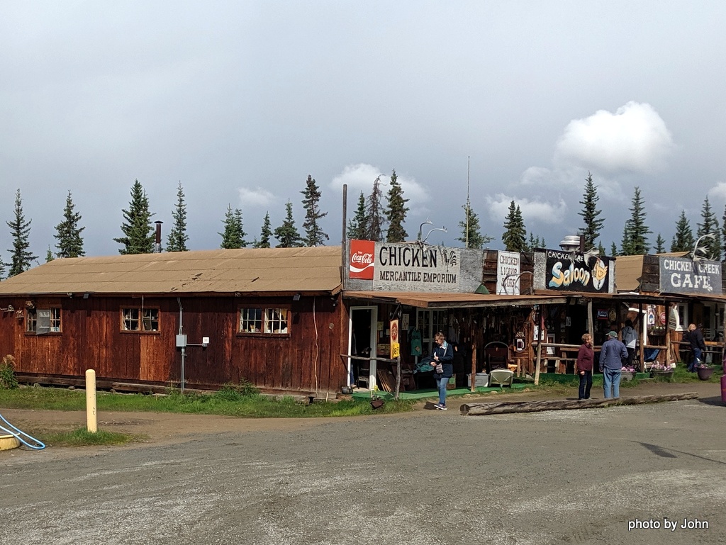
We stopped for a few pictures in Chicken. Obviously, a picture of  "the" chicken was necessary,

but the real reason I stopped here was because I wanted to see the Pedro dredge, still parked where they quit using it.

We'd heard about Susan's chicken pot pie and couldn't resist since it was now approaching 1:30 in the afternoon.

The tour bus that had passed us was finishing up so we didn't have any problem getting a seat. I did, obviously, forget about getting a picture until it was about 75% gone. Huge serving, excellent food, but NOT cheap!

Turk and BJ had to check out the Chicken sled photo opportunity.

My advice - don't try the road unless you're planning to wash your rig, but even in the rain I thought this was a "don't miss it" experience!

In my opinion, the 67 miles of asphalt from Chicken to Tetlin Junction was MUCH worse to drive. Yes it was asphalt, yes it had fewer potholes, but the frost heaves were MUCH worse (although not as bad as the yet to be experienced Tok - Glennallen section!) In my opinion, the gravel is NOT a reason to skip Chicken!

Monday, May 13, 2019

Will Planning Pay Off?

This is my third opportunity to drive to Alaska, the second trip for BJ and the Scamp, but the first since we started geocaching. In addition to the default Milepost and Alaskan Camping books, I've spent a lot of time researching interesting geocaches that might take us to places we wouldn't have visited otherwise.

In addition to earthcaches* and virtual caches** that are often at points of interest, challenge caches*** have influenced the northbound planning. For example, there is a small series of challenge caches about 50 miles south of Reno. Since we haven't driven north that way, we'll route through Reno this time north to see some different country.

There a series of challenge caches near Redmond, Oregon that caught my eye. One is called the NAFTA Trade Route Challenge. It requires that you be able to chain a series of counties together to reach from the Mexican border to the Canadian border. We're missing just one county to make it work - that's right, we need a cache in Washoe County, Nevada (Reno's county) to complete that challenge. (It's the orange one in the map).

Northwest of Kelowna, BC, some geoart caught my eye. The grizzly bear is created from 100 challenge caches but there are some that we'll likely never meet the requirements. Ahead of the bear is another geoart called Run Cacher Run, created from 45 puzzle caches.

I've solved all the puzzles for both the bear and the cacher. The actual locations follow along logging roads outside of Kelowna. We'll spend a day or two cherry picking some of the challenge caches and hopefully complete the RCR art before continuing north.

In addition to all the route planning, we've been busy creating some custom swag to leave along the way.

The southbound proposed routing ignores challenge caches, instead concentrating on coastal views in a few places, more family and friend locations, and a bit of wandering to visit counties that we've rushed through before.

Unlike last time, I don't expect to be as prolific with blog posts, but hope we'll get one posted at least once or twice a week. We've got air in the tires, groceries in the fridge, and water in the tanks. I guess that means we're ready to go.

* An EarthCache provides an earth science lesson through a visit to a unique geological feature.
** A Virtual Cache involves gathering information at the site instead of finding a hidden container.
*** A Challenge Cache requires seekers to find an associated physical cache, and to find an additional set of geocaches as defined by the challenge owner. Challenge caches encourage geocachers to set and achieve fun goals.

Saturday, April 13, 2019

New Shoes

I'd expected to get more miles out of the Goodyear LT265/70R17E tires that came on the truck than I did. I could have stretched a few more miles, but with the Alaska trip rapidly approaching, it was time to bite the bullet.

I fully intended to install what Michelin now calls the Defender LTX M/S because I'd had incredible experience with them on the Tacoma, but the tread life warranty was now only 50,000 miles on the LT version of the tire even though I'd gotten right at 100K on one set on the Tacoma.

I ended up going with the Michelin LTX A/T 2 tire. The tread is more aggressive than the Defender (about the same as the Goodyear LT tire from the factory) but the tread warranty is 10K better while Discount's prices were essentially the same for the two styles, making my decision easy.

The Discount Tire location I use didn't have the A/T 2 in stock in my size but I had a call from them the next morning that they'd come in, so I stopped by and within an hour (in spite of not having an appointment) the tires were going on.

The tread is about as aggressive as the Goodyear tires the truck was delivered with, but they are quieter running.

Meanwhile, I pulled the wheels on the Scamp to check the brakes and bearings but figured it wasn't worth a bunch of pictures. The Timkin bearings that I put in 33,000 miles ago when we returned from our last Alaska trip still look good so they were cleaned, packed, and reinstalled with new rear seals.

One month until we head north.

Saturday, March 23, 2019

Soft Preparations for Alaska

BJ and I have started making preparations for our 2nd Alaska Scamp trip. She's done a few small projects in the trailer, and completed a very interesting quilt while I wasn't paying much attention. Now that much of the quilt construction has moved to the office/guest room, the regular progress is less obvious to me.

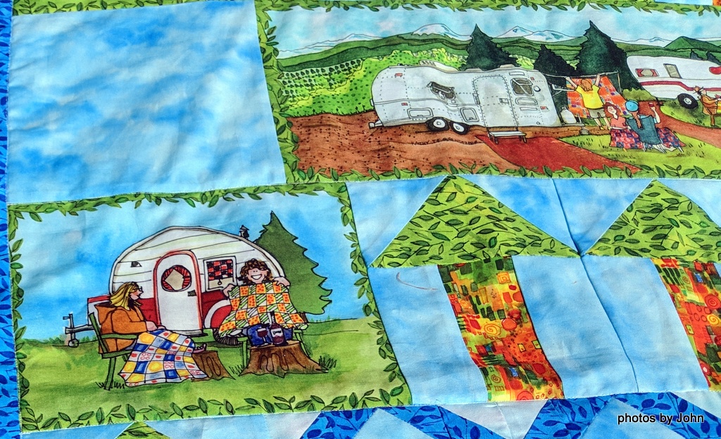
This quilt has all sorts of detail built into it.

Even the back side has an outdoor theme to it. I hadn't intended, but this picture caught that one last pin that got left in until she was folding it after I took the pictures. (As always, you can click on any picture to get a larger version.)

It was only as I was studying some of the panels in this quilt that I realized that she might have a none-verbal message incorporated. I'll let you study the pictures to see what you notice.


I've been working on northbound route planning. Cachetur.no says it's a bit over 4600 miles covering 2 countries, 7 states or provinces, and 44 counties. With 401 potential caches on my list, we'll have a lot we skip, but we'll try to get at least one in every county.

Meanwhile, I need to go back and add waypoints for the quilt shops along the way in case she decides I can go along!

Saturday, December 1, 2018

Thankful

It's that time of year when the sweet oranges ripen. We shared our first one of the season today!

Yesterday, I was out doing some cache maintenance on a very grey morning when I got a phone call from our son saying they'd had a large earthquake but all were OK.

We've all seen photos of some of the major road damage and we're hearing about bridge damage as well. Some folks have suffered significant structural damage to their homes,

while it looks like the only structural issue at our Alaska contingent's place was some shelves in the closet.

We're thankful!

Please pray for all the folks who are significantly impacted and all the work that will be required to return their life to normal.

Saturday, November 3, 2018

Geocaching Alaska

I've been working on qualifying for a couple challenge caches all summer. I 'need' 10 states with at least 100 finds in each state. Another one needs at least five earthcaches in each of 10 states. My plan was to try to get at least 5 earthcaches and at least 51 total additional caches while in Alaska to make Alaska my 9th qualifying state. I tried to concentrate on easy to find caches since I had limited time.

I quickly discovered that Alaska sizes and terrain ratings were suspect. This was supposed to be a wheelchair accessible, regular size. Instead it was small, located 15 feet up a wooded slope.

This one was supposed to be a small, but was a micro lying loose in a hole under the tree. Apparently they don't have problems with pack rats carrying away small shiny things. I logged it and then replaced the old leaves that covered the hole.

This one was supposed to be a "park and grab." I parked, but didn't grab. :-(  I'm sure it's there somewhere...

I do think that caching Alaska in the fall might be easier than any other season. There were some bugs, but not many. The devil's club had died back, making access to some cache locations easier than it would be at other times of the year.

I loved the sign, but it was obvious that the dogs couldn't read. I saw quite a few dogs with their jogging or bike riding  owners, but never saw one on a leash.

Most of the time I was caching alone while Spencer was in school or at hockey practice. I was pretty cautious about the areas I elected to visit.

Never saw a bear, but did see three moose, including one that was closer than I needed to be. I came back to this cache later in the day!

There were some excellent earthcaches, including several that were clustered fairly close together. Each one involved more time and more hiking than I'd expected, but each of them was very interesting and educational.

Spencer and I visited Potter Marsh before one of his hockey games. We were supposed to observe the mountain in the background - not the visible hill, but the cloud shrouded mountain...

Several of the caches were related to the earthquake in 1964. Trees have grown up, camouflaging some of the details but the results are still visible when you know where to look.

I really enjoyed a series of caches around the approach end of the Anchorage airport. Not only were there caches to be found, but you could also do a landing gear inspection on the aircraft as they flew by.

This picture is less about the cache than the Alaskan cacher's attire. These oversize bison tubes were a popular cache container.

We didn't have much time to cache together, but Spencer did manage to get an earthcache and enough other caches to earn a couple souvenirs. Note the difference in desert dweller clothing as compared to the local. The termination dust on the mountains made for chilly temps, I thought...