Wednesday, November 3, 2021

More Labyrinth Canyon

After two nights at a wonderful camp at RM81, we continued downriver. Load out went faster than anticipated thanks to teamwork between the four of us that avoided unnecessary slipping and sliding across the mud at the river edge.

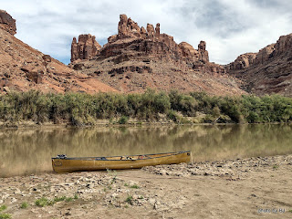
One of the possible advantages of a relatively early start is the beautiful reflections. The downside of an early start when you're trying to stretch out the trip, is you get to where you're going early in the day.

We laid claim to a beautiful sandbar across the river from the Launch Marguerite inscription at about RM73. We had camp set up before lunch and spent the day watching other groups paddle past. This picture was taken after the sun dipped below the western cliffs. Just before dark, a couple gals in a 16' cataraft rowed past. We would see them several more times before the trip was over.

The next morning had high clouds which changed the character of the reflections. We spotted the cataraft at RM71.8 when we went past. Since we'd stayed at Bowknot Bend several times in the past, we all agreed that we would skip it this year. Picking the right line through the shallows near the north side of Bowknot Bend went easier than expected.

We were all dreaming of spending several days at our all-time favorite campsite but were concerned with the number of parties that had passed us in the past 48 hours. In the spirit of going slowly, we decided to add an night on the mid-river sandbar just downstream of the large heart-shaped rock on the east side of Bowknot Bend at about RM66.7.

The sandbar had a three inch layer of very slippery mud, but someone had cleared a path down to solid sand in one spot so we unloaded the canoes, one at a time.

About 4:30 or so, the cataraft that had passed us late yesterday landed at a high camp on river right just upstream of us. We've always stayed hard left in this section so I'd never noticed the access before. Maybe next year, since there is a history of mining in that area.

We'd agreed to take our time the next morning, waiting for the sun to hit our tents and dry the condensation from the rain flys before loading. Much to my surprise, the gals with the cataraft were up early and on the river while we were eating breakfast. We knew they were headed to Cataract Canyon, so we didn't think much about it. With just five miles or so to our desired destination, we dawdled and drifted past the south side of Bowknot Bend.

Home for the night was not our desired location, but rather a sandbar midriver near the mouth of Twomile Canyon. The cataraft was unloading at our desired camp as we went by. Turns out, the typical sandbar that shortens the climb up the bank was gone this year so getting into that camp would have been a lot of work. Such is the luck of the draw! Once again, a beautiful sandbar camp but not one that was worth spending another day or two.

The next morning, we continued downriver, looking for any spot that said "stay here another night" but instead we watched the light changing on the cliffs and the shoals leaving little telltale signs of their existence.

We arrived at Mineral Bottom as several groups were spread out across the launch ramp. We waited and watched and were thankful that it wasn't our canoes that they were dragging fully loaded down the launch ramp.

The truck shuttle worked out wonderfully. It was parked where we expected, and even though we were off the river two days earlier than hoped, it made for easy loading up. Nice timing, too! Just as we were leaving, 3 trucks pulled in towing NPS J-rigs and once again the launch was a busy place.

This was the part I'd been waiting for. We've always used an outfitter for the shuttle but this time I got a chance to drive. It's true that there'd been a slight washout a couple weeks prior, but in this case the GPS is referring to a geocache named Washout!


Since I was driving, I got to stop and take pictures along the way. Fair to say, the road is crooked and steep. I'll be back someday with the Silver Subie to spend some time exploring Mineral Bottom and the surrounding area.

As always, you can click on a picture to get a larger version.


Tuesday, October 19, 2021

Better Late Than Never

I've been very lazy about doing any blogging, but I realized that I use my blogs to keep track of our travels. We did our nearly annual Green River trip again this year, with a bit of an interesting twist. We headed north on September 21st this year. As typical, we left home well before the sun came up, with about 550 miles to go before we could rest.

This year we decided to do the Labyrinth Canyon section from Ruby Ranch to Mineral Bottom. Instead of getting hotel rooms in Moab and using our typical shuttle service, we headed all the way to Ruby Ranch and camped at the put-in. 

The next morning after breakfast we broke camp and loaded the canoes. We were on the water about the time we would normally have left Tex's Riverways Office. But what about the truck?? This year we used Coyote Shuttle to move our truck from Ruby Ranch to Mineral Bottom. It worked out really well, and the truck was waiting in the parking lot when we got to Mineral Bottom.

We had a plan, but it went up in smoke when we arrived at Trin Alcove. More often than not, Trin Alcove has a big berm of high, dry sand across the mouth of the wash. The plan was to spend two nights here. This year, there'd been a massive flash flood and there wasn't any sign of sand! The mud was very slippery and very deep if you weren't careful. Clearly, we weren't going to stay here!

We continued downstream, watching for an accessible sandbar and enjoying the wonderful weather.

We found a nice spot on river left across from June's Bottom at about river mile 88.5. The sandbar had a 12 inch lip and a good solid sandy bottom along the edge. Easy unloading. By noon we had shade structures up and the lunch bags out. This picture, taken about 5:30, shows the afternoon shade starting to cover our home. 

When the cliff was in full sun earlier in the afternoon, we spotted this inscription from camp so I had to check it out. Over 20 years of Green River trips and I'd never noticed it before. I've not been able to find any info about it. As usual, you can click on the picture for a larger version.

While we'd planned 2 nights at Trin, we decided one night at the sandbar was enough since there wasn't any shade nor anything to explore other than the inscription. The next morning we were on the river again. The thought was that we would stay about river mile 84 if it was available. 

There were three guys camped at the high camp at RM84, so we stopped long enough to find a geocache that's been there since 2003 and then continued downriver. From looking at the paper log versus the on-line log, it looks like a number of people are mistaking the BLM ammo can with info about graffiti for the geocache. 

We ended up at a wonderful, shady camp at RM81. We'd stayed here on our 2018 trip and really liked it. The cliffs on the back side of the bottom are full of very intricate tafoni.

Perhaps the reason the camp was available (other than the "before lunch" arrival) was that cattle had been accessing the river at this point, leaving very slippery "mud" that reminded me of my childhood, feeding heifers. It was worth the effort for a great two night stay.


Tuesday, July 27, 2021

Ida UhOh!

After a couple more days in Spokane with my brother and his family, it was time to see if I could finish off all the remaining counties in Idaho. With the exception of one that was so weathered that it was difficult to read, all the historic markers in Idaho were large and clear. The best part was that many had a geocache nearby.

Some signs were easy to read, but after I stopped, I wasn't sure what the other sign was supposed to say.

This one, and several others like it, were easy enough to read. Not sure why the geocache was ALWAYS past the sign...

Some signs seemed to be primarily targets. How long has Bell Telephone Company been gone?

I enjoyed some beautiful gravel roads up and over massive hills. They'd had a bit of rain in the recent past, so in most cases, the gravel roads were nearly dust free.

My favorite boondock of the whole trip was here, alongside another minimally travelled gravel road east of Emmett. The sunset was beautiful, but it was the hour+ long conversation with the landowner that made it special. His family had been on the land for four generations and it was clear that he loved the land.

Cleaning up counties in Idaho isn't easy because all the valleys and rivers run north to south so I'd drive up one valley to a pass, and then down the next one, slowly working my way east.

Every now and then I'd stop just because the old buildings spoke to me. I wonder about the stories to be told about settling this land.

Most of the geocaches were non-descript, but someone put a lot of effort into this waypoint for a cemetery multi-cache.

It was about this time that the Silver Subie started showing signs of ill health. Clutch travel was slowly, but noticeably, changing. I got as far as a series of challenge caches outside of Atomic City when I decided I couldn't ignore it any longer.

After a consultation with the Subaru dealer in Pocatello when the Service Center opened - a consultation that primarly consisted of "we can't look at it until early next week" - I pointed the car towards home. The plan was to see how far I could get before I needed to put it on a trailer.

Utah wasn't in the route plan this year, but it was the shortest and fastest way home!

It was a 981 mile day, but I got home that evening without needing to trailer the Subie. I parked it in a corner and put the dunce cap on it. It will get some attention one of these days soon.

Unfortunately, it means that I have three counties orphaned in eastern Idaho. Obviously, I'm going to have to go back - maybe next summer.

Monday, July 12, 2021

Wandering the Northwest

After a good night's sleep at a boondock north of Brookings, I continued to pick off my missing Oregon counties with a drive up Highway 101. I had most of the counties, but that wasn't going to stop me from enjoying the view.
There's a little arch in the rock down at water level that I never would have noticed except for the virtual cache that mentioned it.
I took advantage of some state forestry land east of Eddyville for another good night's sleep. As all good boondock spots, it was far enough from the highway to mask the noise and had good connectivity so that I could get my caches logged. 

The next morning I started with a visit to the University in Corvallis so I could get my picture taken - twice. There are two surviving webcam caches here!
I snagged a whole batch of well maintained challenge caches near Talent, Oregon and spent a couple hours with a very good friend in Newberg before heading to Scappose. The plan was to work a challenge trail there, but after getting "enough" to claim the county I left since they appeared to be very poorly maintained. Home for the night was another boondock near Cathlamet, Washington.
With my typical early start, I headed up the Columbia, first on the Washington side, and then switching to the Oregon side.
That afternoon found me working a challenge trail in the high hills west of Milton-Freewater, Oregon. I took advantage of one of the several snow parks along Highway 204 for my home for the night. Once again, I picked a spot with no one around, no noise, and decent connectivity.
The next morning I finished up the last of my Oregon counties and started on the ones that I'd ignored in SE Washington. The caches weren't memorable, but I loved my time in Pomeroy. There was a large collection of classic signs and antique vehicles that deserved more time than I gave it!

The Subie started sqawking at me a bit, so I changed up plans and headed to Spokane, making sure to pick off my last two SE Washington counties along the way.
After a couple layover days with my brother and sister-in-law in Spokane, and a quick, easy fix that was much easier in their garage than at my planned boondock, it was time to head north and west. For some reason, in spite of visiting both several times, we'd never logged caches in Ferry or Okanagan counties, so I fixed that oversight.
As I was wandering across the northern expanse of the state, I realized that I was approaching a milestone. Facing a series of challenge caches, I shuffled the sequence because I thought the name of this one pretty well summed it up!
With the milestone out of the way, and rain coming down, I had my pick of campsites at South Grandy Lake along the road to Baker Lake. At least I know how they keep things green and mossy!
I had one more county to complete my Washington counties, and it involved ferries. Parking at the ferry terminal cost nearly double what my walk-on ticket to Friday Harbor cost. I found all of the caches I looked for within reasonable walking distance, and then wandered around town, amazed at the changes since I'd last visited.
After a morning meet & greet with several folks from Geocaching HQ, another reviewer, and some other cachers, I chased around visiting some of the high favorite caches in the greater Seattle area and ended that day with a very nice boondock overlooking a full (seems like the stumps are showing usually) Lake Keechelus in preparation for a priority.
I started through the tunnel at 5:30 a.m. and had the whole hike (both ways) all to myself. The goal was a very rare geocache. BJ and I had visited several years ago but the cache was missing at that time, so it was nice to come back and log one of the two remaining Project APE caches. After the APE cache, I visited the challenge caches in the area and then headed back to Spokane.

Saturday, June 19, 2021

Cleaned up California


I left home early on June 2nd, headed for Taft, California. I routed via Palmdale in order to avoid LA traffic. I was hoping to spend more time checking out the Blackbirds on display but the museum was not open.


I needed to route through San Francisco, but I'd already decided to NOT try to get down to the iconic Fisherman's Wharf. Instead, I found a cache highlighting some of the murals. There were some very talented painters represented.


I hadn't been through wine country in decades. The architecture of wineries was varied and interesting, but the rusty truck statue in Calistoga caught my eye.


I think one of my favorite caches in Northern California was one dedicated to the Unknown Stage Robber. It was tough to find with terrible coordinates, but it left lots of thoughts about times past.


The last county I needed to finish California was Siskiyou County. The cache at the Hayden Hotel was nondescript, but the history it highlighted was interesting. The road was slow and the trees were beautiful.


The 58 California counties have now been officially visited! The chasing counties concept worked - I enjoyed lots of back roads that I wouldn't have visited otherwise.

Thanks to the temperatures, I sprung for a hotel for the two nights in Taft, but was able to find comfortable, safe locations to boondock the other 4 nights in California. Silver Subie for the win.