Tuesday, June 30, 2015

Where’d the Burros Go?

We stopped by the Giant station in Show Low to fill up with gas and take advantage of their free dump before heading off to our next camp. Los Burros is located seven miles up a wide gravel road from the town of McNary. The road goes by various names: Vernon – McNary Road; County Road 3140; and Forest Road 224.

Los Burros is one of those rapidly disappearing campgrounds that is still operated directly by the Apache-Sitgreaves National Forest instead of being leased to a commercial operator. There are 12 designated sites and a volunteer camp host who has hosted at this campground for three or four years. There’s no water,

no garbage, no fee, and very nearly no cell connectivity, even with the amplifier and antenna.

There is a vented outhouse, tall pine trees, and a huge, open meadow that should attract wildlife although we haven’t seen anything except an occasional squirrel. We haven’t seen any sign of burros, but there are a couple small corrals if you bring your horses along.

The iris were blooming in the meadow

and the dandelions were blooming everywhere – enough that BJ’s allergies were taking note. The grass in the meadow and many of the sites was knee high.

This area was originally a guard station with a now boarded-up cabin,

a small spring that helps keep the meadow green,

and a barn built in the early 1900s for the ranger who rode to the top of the nearby mountain and climbed a tree to see if there were any fires around.

There is a trailhead at the end of the campground that accesses the extensive (and well documented) White Mountains Trail System. The trail system is maintained for equestrian, foot, and mountain bike use although the section I hiked didn’t show any signs of equestrian use.

At 7800’ elevation, we experienced warm days, blue skies, and nice cool nights in mid-June. Daytime breezes were enough that the awning was stowed within hours of arrival. Unfortunately, after three days, we pulled up stakes and headed east, looking for a place with fewer allergens.


Sunday, June 28, 2015

Wandering, With A Destination In Mind

The grandson is scheduled to arrive soon, so BJ and I took advantage of our Arizona high country wandering to practicing locating geocaches. It was a good excuse to wander some forest roads, to learn some bits of history, and to see places we likely wouldn't have seen otherwise. 'Sides that, we located a bunch of geocaches, including some that hadn't been visited for a year. (We visted a couple had hadn't been found for a couple years - we didn't find them either!)

One of the roads we followed was part of the General Crook Trail, complete with markings on the trees to keep you on course. Lots of the roads showed signs of being very muddy when wet, but were easily passable with the 2wd truck since the roads were dry. As always, click on the pictures for a larger version.

Our travels took us to two fire lookouts. Deer Springs has a small cab with a cabin on the ground provided for the lookout. It was near the Big Fire multiCache. Juniper Ridge has a much larger cab, with the lookout living in the cab while on duty. The Juniper Lookout Toy Cache was nearby.

We visited several windmills including this wood frame with all the windmill mechanism long gone. The top portion of the stone lined well casing was still visible. It was located near the Windmill Cache. The cache hadn't been visited for nearly a year. The nicely named WELL! How About That? cache was worth the drive for the view, but wouldn't have been an option for us in the wet season.

The small town of Pinedale honored their history by constructing this monument to display their original school bell. The bell was purchased in 1892 and served at three different school buildings before ending up here near the Back To School cache.

All told, we located at least 16 caches while camped for 6 days at the lovely Grover Spring Canyon boondock site. There are lots more that could be found, but it's time to empty the black tank and look for a location with even more elevation.

Friday, June 26, 2015

Aripine, AZ


In the process of trying to find (unsuccessfully in this case) a geocache (GC30ZBN), we ran across the remnants of the town of Aripine, Arizona. I'd never heard of it. Based on web research, it looks like most other people haven't either. There were a few old log cabins with newer sheet metal roofs.

Aripine shows up in a couple "ghost town" websites with minimal information, but it does have its own zip code. Google Maps suggests that the stone house served as the post office at one time but I'm betting it was the stone building to the left of the house.

There were a few newer homes in the town, with a chain across the driveway. We didn't see any sign of anyone residing in the town the day we were there.

I especially liked the gate structure at the stone house near the intersection. The rock work included lots of pieces of petrified woods. It's a long ways by road but not so far as the crow flies to Petrified Forest National Park. It leaves one to wonder the source of this petrified wood.

The best part of the open gate was the nearly unreadable No Trespassing sign! (As always, click on the photo for a larger version.)

There's obviously been a livestock operation at one time. A concrete silo was still standing, but this loading chute had seen its better days.

Apparently, Aripine was best known for the Sundown Girls Ranch. It was quite popular 50-60 years ago with girls (and a separate ranch for boys) from eastern cities. The girls ranch still shows on the map, but it's not clear if it's in operation.

Usually, the story of a ghost town can be determined in part just by looking around. This one is more perplexing since there are essentially three different era of structures - log, stone, and frame construction - yet no one is home.

Wednesday, June 24, 2015

Home in the Pines

June 10-15 - The last three years, we've managed to be out of the Valley of the Sun for some or all of the summer. This year we've stayed closer to home, but it hasn't taken me long to remember why I prefer to be somewhere else during the summer.

With the theory that elevation makes for cooler weather, we headed to the Mogollon Rim. I knew that all the areas around Woods Canyon Lake would be crazy busy and besides that, they now charge for boondocking along that section of the rim, so we kept going.

Thanks to Campendium, we knew that there were some spots near Forest Road 139 that looked like they be positioned nicely for some geocaching and general wandering around. There was no review, but Brian had posted pictures when they were in the area a couple months ago.

Campendium's marker is at the intersection of Forest Road 139 and the unmarked Grover Spring Canyon road. The first spot on the unmarked road (about .1 mile from the intersection) was taken and the fellow there said I was the first traffic he'd seen in a week - that's good! We settled in to the second spot, about 1/4 mile from the intersection. It took some shuffling to get turned around and get the trailer situated for the solar panel. We're in the shade in the morning,

but the panel is nicely lit from mid morning to later afternoon in spite of the pine trees around us.

The Grover Spring Canyon road (which doesn't show on the Apache-Sitgreaves National Forest Visitors map) crosses the Grover Spring wash immediately south of our spot. There are at least two more spots south of the wash crossing if you have enough clearance to deal with the edge of the wash. That road becomes a very rough, shoulda been 4wd road within .3 miles. I survived it, without the trailer, but only because our Tacoma has a locking differential.

In addition to the spots along Grover Spring Canyon road, there is one easy to access spot on FR139 just south of Highway 260 that is out of sight of the highway but likely subject to some road noise. Most of it is sloped but the corners flatten out considerably.

We have 3 bars of Verizon 3G, 2 to 3 bars of AT&T Edge, and 3 bars of Verizon 4G with the Sleek amplifier and antenna deployed.

It's too bad all our winter visitor friends miss out on the beauty of Arizona high country! This spot at about 6600' elevation makes for wonderful 80 degree plus/minus days and 50 degree nights. Can't ask for more!

Monday, June 22, 2015

I'll Take That Discount!

June 11 - I've bought all our tires from Discount Tire for the past 25 years. Initially, it was because they were conveniently located. Then it was because they had a large network of shops and an excellent road hazard warranty. They've always treated me better than I expected. So... here's the rest of the most recent story.

When we got all situated at our boondock site between Heber and Show Low and were getting ready to go out for a drive, BJ noted a nail in my right front tire.

The tire was holding pressure, but BJ looked up the closest Discount Tire store and we headed to Show Low with the intent to get the tire patched under their road hazard warranty. We'd barely gotten out of the truck when one of their people came out to ask how they could help. He took one look and said, "Your tires are getting well worn." No surprise - they had 77,000 miles on them but I got right at 100,000 on the previous set and I keep toying with selling the truck.

Then he said, "The sidewalls have a lot of ozone checking." Yup, that's true. The truck has been outside the whole of this set of tire's life. According to him, ozone checking is covered under the road hazard warranty. Who'da thunk?

In short order, the truck was in the shop getting a whole new set of shoes. The cost to me was the road hazard warranty on the new tires, the lifetime balancing & rotating, and the difference in tax between the removed set and the new set.

The crew dismounted the old tires and mounted up the new tires,

spin balancing each one.

BTW, did you know that nearly all towable RV manufacturers don't balance the tires they put on their trailers? Apparently since people don't ride in the trailer they don't care. Seems crazy to me!

For less than the cost of one tire, the truck has a set of new Michelin tires. I sure hoping that I don't keep it long enough to see how long this set lasts! They had us on our way just one hour after we arrived.

I don't have any connection to Discount other than as a very happy customer! They've got my business!


Saturday, June 20, 2015

Where Have I Been?

I've camped all my life - everything from backpacking to car camping to RVs - and have enjoyed various forms of dutch oven cooking for the past 15 years, but I'd never heard of hobo pies. This is another thing I learned from my grandson while in Alaska.

For those of you that may be as illiterate as I am about the finer things in life, the hobo pie maker is most often constructed from a pair of hinged cast iron pans mounted on long rods. Rome seems to be the most common manufacturer. They're available at Amazon and some of the big box outdoor retailers.

Since Spencer was demonstrating proper usage of the implement, cherry pie filling became the filling of choice. It could just as easily been ham & cheese, or chili and cheese, or ...

Buttered side of the bread down, then the chosen filling,

and then the other piece of buttered bread.

Close it up and hope for the best. I guess your nose will tell you if you keep it in the fire too long. Speaking of fire, we're planning to test ours over a propane burner using ciabatta bread, ham, and cheese. There may be pictures or maybe not...

This is the best picture I have of Spencer's product. Once you bite into it, there's no sense setting it down to take a picture!

Home for one night while taking hobo pie lessons was the NFS Porcupine Campground located at the end of the road just outside of Hope, Alaska.

And here's a couple pictures of our first solo test while we were camping in Arizona's high country. Thanks, Spencer!

Thursday, June 18, 2015

Greedy Trees

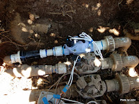
Our lime tree has produced bumper crops the last couple years. Now I think I understand why. When I got home from Alaska, BJ mentioned that the drip system for the flower beds was not shutting off. That usually means there's a very small stone somewhere in the valve. I expected an easy fix, but when I pulled the cover off the valve box, I discovered three inches of water standing in the bottom of the box, and the flower valve leaking at its outlet. Its apparently been doing that for years!

On closer inspection, it seems that the tree has grown a large root that pushed against the side of the valve box, putting pressure on the control valve closest to the side of the box – the flower valve, of course!

The next challenge was that the box needed to be dug out so that the root could be “modified” and the valve replaced


It’s going to be interesting to see how the greedy tree does with a big chunk of root amputated. I’m sure the effect will show up in the tree, and rather soon I’d expect.

The box is back in place, everything is working, and I’m wondering why I’m working on drip systems when we could be somewhere cool.

Tuesday, June 16, 2015

Reflecting on Service

Twenty years ago, BJ started getting serious about her hiking interests, mentored by a wonderful former backcountry ranger in the Grand Canyon.

Fourteen years ago we moved to East Mesa so that we would be closer to the river and so that BJ could join the Search & Rescue group active in the Superstition Mountains.

Through the years, organizations and people have changed, but she continued to do what she could to be available when needed for searches and rescues. Years ago she had one knee surgery and now it's starting to act up again. Meds help, but she's also more careful about how she uses it.

A month or so ago I asked if we could do a day hike somewhere in her stomping grounds.

We took the short route to Hackberry Spring. Like so many places in the Superstitions, it's a well known route but not an official trail. We started off on an old jeep road to a corral and windmill remains that predate the Wilderness designation.

I'm guessing that the corral and structures were build in the 60's or 70's given the use of old railroad ties for posts and the condition of the sheet metal on the shade structure. It was old enough to show lots of weathering, but certainly not "historic."


First Water creek wasn't running, but there were still quite a few pools with water.

Once in a while we'd spot a cairn although for the most part they were unnecessary. The route follows the wash which was very well defined.

Sometimes the route was across bedrock, sometimes a bit of sand. Most of it was across fairly large cobble. The creek clearly gets some major flow occasionally!

Hackberry Spring is a small pool up against the cliff, with a small pipe dripping out the overflow. It would be easy to miss since it's hidden behind some trees but the moisture does extend towards the wash, given the position away. While we were there, a small group of young people arrived, approaching it from downstream as part of the longer loop route.

We were blessed with a wonderful day. A few light clouds, and relatively cool weather. Well worth being on the trail at 7 a.m.!

The leaning rock was easy to spot as we headed back up the drainage. It's not obvious when headed down the drainage - hidden by the larger cliff.

All in all, a wonderful hike. While she really enjoys it, I sometimes wonder how much longer BJ will remain an active SAR member. She has met some wonderful people who are now close friends through her involvement and service but change comes no matter if you want it or not.