Showing posts with label Utah. Show all posts

Wednesday, November 3, 2021

More Labyrinth Canyon

After two nights at a wonderful camp at RM81, we continued downriver. Load out went faster than anticipated thanks to teamwork between the four of us that avoided unnecessary slipping and sliding across the mud at the river edge.

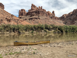
One of the possible advantages of a relatively early start is the beautiful reflections. The downside of an early start when you're trying to stretch out the trip, is you get to where you're going early in the day.

We laid claim to a beautiful sandbar across the river from the Launch Marguerite inscription at about RM73. We had camp set up before lunch and spent the day watching other groups paddle past. This picture was taken after the sun dipped below the western cliffs. Just before dark, a couple gals in a 16' cataraft rowed past. We would see them several more times before the trip was over.

The next morning had high clouds which changed the character of the reflections. We spotted the cataraft at RM71.8 when we went past. Since we'd stayed at Bowknot Bend several times in the past, we all agreed that we would skip it this year. Picking the right line through the shallows near the north side of Bowknot Bend went easier than expected.

We were all dreaming of spending several days at our all-time favorite campsite but were concerned with the number of parties that had passed us in the past 48 hours. In the spirit of going slowly, we decided to add an night on the mid-river sandbar just downstream of the large heart-shaped rock on the east side of Bowknot Bend at about RM66.7.

The sandbar had a three inch layer of very slippery mud, but someone had cleared a path down to solid sand in one spot so we unloaded the canoes, one at a time.

About 4:30 or so, the cataraft that had passed us late yesterday landed at a high camp on river right just upstream of us. We've always stayed hard left in this section so I'd never noticed the access before. Maybe next year, since there is a history of mining in that area.

We'd agreed to take our time the next morning, waiting for the sun to hit our tents and dry the condensation from the rain flys before loading. Much to my surprise, the gals with the cataraft were up early and on the river while we were eating breakfast. We knew they were headed to Cataract Canyon, so we didn't think much about it. With just five miles or so to our desired destination, we dawdled and drifted past the south side of Bowknot Bend.

Home for the night was not our desired location, but rather a sandbar midriver near the mouth of Twomile Canyon. The cataraft was unloading at our desired camp as we went by. Turns out, the typical sandbar that shortens the climb up the bank was gone this year so getting into that camp would have been a lot of work. Such is the luck of the draw! Once again, a beautiful sandbar camp but not one that was worth spending another day or two.

The next morning, we continued downriver, looking for any spot that said "stay here another night" but instead we watched the light changing on the cliffs and the shoals leaving little telltale signs of their existence.

We arrived at Mineral Bottom as several groups were spread out across the launch ramp. We waited and watched and were thankful that it wasn't our canoes that they were dragging fully loaded down the launch ramp.

The truck shuttle worked out wonderfully. It was parked where we expected, and even though we were off the river two days earlier than hoped, it made for easy loading up. Nice timing, too! Just as we were leaving, 3 trucks pulled in towing NPS J-rigs and once again the launch was a busy place.

This was the part I'd been waiting for. We've always used an outfitter for the shuttle but this time I got a chance to drive. It's true that there'd been a slight washout a couple weeks prior, but in this case the GPS is referring to a geocache named Washout!


Since I was driving, I got to stop and take pictures along the way. Fair to say, the road is crooked and steep. I'll be back someday with the Silver Subie to spend some time exploring Mineral Bottom and the surrounding area.

As always, you can click on a picture to get a larger version.


Friday, October 19, 2018

Arches

We took an extra day in Moab to visit Arches National Park. In spite of the many times we've been to and through Moab, we'd only visited Arches once - 10 years ago. We'd observed the lineup at the toll booth going to and from the river so we decided to get a reasonably early start. It was approaching 8 a.m. when we stopped at the viewpoint to look down on the highway and the Moab fault.

While the cliffs in Arches look similar to the cliffs lining the Green River at first glance, they are from a very different rock layer and much more prone to erosion and arch formations. (The canoe made the truck easy to pick out in the parking lots!)

Our initial destination for the day was the Delicate Arch hike, but we had to check out the petroglyphs on the way.

The Delicate Arch trail is 3 miles round trip with 480 feet of elevation gain. Early in the hike there was a section with built-up stairs.

And later, a short section with stair carved out of solid sandstone,

but the majority of the trail was across sloping slickrock, complete with occasional trail signs in 5 gallon buckets of rock. The signs made a great spot to take a breather and eyeball where the trail went next. There was one section where the trail was on a (wide) ledge blasted out of the cliff.
My first view of Delicate Arch was through a window a short scramble up from the trail. In spite of widespread reports in 2011 (mostly dated April 1), the arch is still standing!

We took the obligatory selfie to claim the virtual cache,

and did the necessary research to claim the earth cache associated with the arch. Ten years ago, I didn't make the effort to do the hike, but by getting an early start, the temps were comfortably cool and the hike was well worth it.

From a photography perspective, it seems that sunset might be optimal since the arch is backlit in the morning.

On the way back down you could look out across the valley to see where we'd parked.

It always amazes me where junipers can gain a toehold!

I'd hoped to do some other short arch hikes, but we'd spent a couple hours on the Delicate hike and by 10:30, it seemed that every parking spot in the park was full. We drove out to the end of the road at the Devil's Garden trailhead thinking fewer people would be there but it was just as insane, complete with tour bus loads of people,

We made a pass through the Windows section of the park in time to join the traffic jam.

We snapped a few pictures through the truck windows and by noon decided it was time to call it quits. We could hear Edward Abbey flopping around in his grave!

My takeaway was to plan on doing one hike a day, and plan to be at the trailhead by 8 a.m.

We did enjoy our hike and wonderful wood fired pizza at Antica Forma (not cheap, but oh so good!) so the day was definitely not a bust!

Sunday, October 14, 2018

Buzz Job

It was only after we had the boats loaded and we were a mile or so downriver from our camp that the dark clouds decided that they actually did contain some rain. I thought about digging out my rain gear, but it was warm so we paddled on.

Within 20 minutes or so, the skies cleared and the sun came back out. It seemed only appropriate with with 8 nights of camping on the river, we should have a few minutes of rain.

We arrived at Mineral Bottom a day early, simply because it is easier to avoid the hassle of a busy ramp and risk of upstream winds for the last morning.

A group of paddlers from Phoenix camped about a mile downstream of us last night but hadn't broken camp when we passed this morning. We had our boats cleaned and stowed when they starting arriving at the Mineral Bottom boat ramp.

We'd been buzzed by a Mooney M20 at our last camp, and then by a Husky and a Super Cub during our paddle from our RM61.5 camp. In the afternoon, a couple different planes flew over, checking out the Mineral Bottom airstrip.

A Super Cub landed first, followed by a Maule 180. Later, a couple Kitfox homebuilts made multi passes at the airstrip. Finally, one of them attempted to land, but was downwind. We couldn't see the landing, but we could hear it. Some of the sounds were not congruous with normal landing sounds. A bit later, the other Kitfox landed.

At 7 a.m. the next morning, I walked over to the airstrip (about 3/4 mile from the boat ramp) since I had a couple decent pictures of the Maule on approach that I thought the pilot might like.
The signage for the airport is pretty tired, but the strip looked great - at least when it's dry. It's 2000' long, and wider than I expected. It would be really soft and slippery when wet. Turns out, all the pilots were planning to camp at the airstrip overnight.

The pilot of the Maule was making his morning coffee when I got there. We had a very interesting chat about his flying trip to the southwest, specifically to visit some of the back country airstrips around the Four Corners area. He was heading to the area around Page, Arizona next.

Turns out, there was a reason for the incongruous landing noises from the first Kitfox. Somehow, the pilot managed to avoid any apparent wingtip damage, but was very successful in removing the main landing gear in a manner that wouldn't be considered appropriate by the aircraft designer. The question the pilot asked me was could a 20' trailer be towed down the road to Mineral Bottom. Looks like this one is going home in a different manner than it arrived.

After the shuttle back to town, we ended up back in the very same site at Pack Creek Campground that we'd been in before we left for the river. Pack Creek was willing to allow our trailer to stay in their overflow area while we were on the river.

The parking lot was full to the brim at the place that we normally enjoy our after trip dinner so we headed to the Moab Diner which has wonderful green chili and amazing desserts at very competitive prices.

When was the last time you saw a real (and BIG) banana split for less than $5?

There were only three desserts - apparently someone who will remain unnamed was still on a river diet.

Tuesday, October 9, 2018

Leaving a Mark

One of the reasons to camp at Bowknot Bend was to hike up to the ridge in the morning while it was cool. BJ & Willie decided that they would take a pass, so Kathy and I headed off before breakfast.
I'd considered hiking up for sunrise but decided that going early enough to enjoy the cool shadows was good enough for me. Since our camp was on the north side of the neck of the bend, we got a light show on the cliffs across the river but stayed cool in camp.

The first time I climbed to the ridge, there was a very rough trail but no steps. Last time, there were a few steps. This time, the trail was much better, very obvious, and there were lots of places where sandstone blocks were used to create very nice steps.

At the west end of the ridge, there is an area with some old river runner glyphs. Rumor has it that John Wesley Powell's group left their mark but we couldn't find it. The very clear and clean Kolb Bros mark (famous Grand Canyon photographers) was obvious with junk from the past 20-30 years starting to crowd it out.

The (Harry) Aleson, (Georgie) White inscription is very clear. This one was placed when they were doing one of the earliest military surplus raft trips from Green River, Utah to Hite. Later, Georgie became famous for her 'triple-rigged' inflatables that carried scores of people through the Grand Canyon.

This one looked very well done. I was debating who ATH was, and then I looked closer. This was was done with power tools, grinding the deep inscription in 2003.

This one was scratched into the desert varnish. I'd like to think that by this time, the whole concept of  'leave no trace' should be well know - apparently not to Reese!

It make one wonder how long forever was/is for T & A.

Interestingly enough, not only are some people still leaving their mark on the cliffs, someone/s was also leaving their mark (and the used toilet paper) in places near our camp in spite of the requirement to have a washable toilet system and to carry out all solid waste. Some people make me angry!

I had to try a panorama. This one is taken facing west where the trail first reaches the ridge. On the left is the downstream side with our next camp in the shadows of the downstream cliffs. On the right is the upstream side of the bend. The river travels about 6.5 miles to make it around the bend, passing less than 1/4 mile from itself. As always, clicking on a picture will bring up a larger version.

After two nights at Bowknot Bend, we continued downriver to river mile 61.5 where we were able to snag another beautiful high water camp, complete with an excellent sandbar out front for unloading and bathing. The ridge at Bowknot is the low part of the ridge in the background.

The best part of this camp was the shady 'porch' where we could sit and watch the river flow by. There was just enough vegetation that many people wouldn't notice you until you spoke to them.

We were really impressed with a group of five families, complete with at least 12 children of all ages, that drifted past us using all manner of floating devices. They were spread out enough that we never could get a picture of the whole group.

This is a popular camp for Boy Scout trips. Unfortunately, the area was marred by MANY people leaving their marks on the walls. I spotted at least one large one that was dated 2017. I don't understand...