Showing posts with label Green River. Show all posts

Wednesday, November 3, 2021

More Labyrinth Canyon

After two nights at a wonderful camp at RM81, we continued downriver. Load out went faster than anticipated thanks to teamwork between the four of us that avoided unnecessary slipping and sliding across the mud at the river edge.

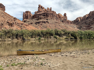
One of the possible advantages of a relatively early start is the beautiful reflections. The downside of an early start when you're trying to stretch out the trip, is you get to where you're going early in the day.

We laid claim to a beautiful sandbar across the river from the Launch Marguerite inscription at about RM73. We had camp set up before lunch and spent the day watching other groups paddle past. This picture was taken after the sun dipped below the western cliffs. Just before dark, a couple gals in a 16' cataraft rowed past. We would see them several more times before the trip was over.

The next morning had high clouds which changed the character of the reflections. We spotted the cataraft at RM71.8 when we went past. Since we'd stayed at Bowknot Bend several times in the past, we all agreed that we would skip it this year. Picking the right line through the shallows near the north side of Bowknot Bend went easier than expected.

We were all dreaming of spending several days at our all-time favorite campsite but were concerned with the number of parties that had passed us in the past 48 hours. In the spirit of going slowly, we decided to add an night on the mid-river sandbar just downstream of the large heart-shaped rock on the east side of Bowknot Bend at about RM66.7.

The sandbar had a three inch layer of very slippery mud, but someone had cleared a path down to solid sand in one spot so we unloaded the canoes, one at a time.

About 4:30 or so, the cataraft that had passed us late yesterday landed at a high camp on river right just upstream of us. We've always stayed hard left in this section so I'd never noticed the access before. Maybe next year, since there is a history of mining in that area.

We'd agreed to take our time the next morning, waiting for the sun to hit our tents and dry the condensation from the rain flys before loading. Much to my surprise, the gals with the cataraft were up early and on the river while we were eating breakfast. We knew they were headed to Cataract Canyon, so we didn't think much about it. With just five miles or so to our desired destination, we dawdled and drifted past the south side of Bowknot Bend.

Home for the night was not our desired location, but rather a sandbar midriver near the mouth of Twomile Canyon. The cataraft was unloading at our desired camp as we went by. Turns out, the typical sandbar that shortens the climb up the bank was gone this year so getting into that camp would have been a lot of work. Such is the luck of the draw! Once again, a beautiful sandbar camp but not one that was worth spending another day or two.

The next morning, we continued downriver, looking for any spot that said "stay here another night" but instead we watched the light changing on the cliffs and the shoals leaving little telltale signs of their existence.

We arrived at Mineral Bottom as several groups were spread out across the launch ramp. We waited and watched and were thankful that it wasn't our canoes that they were dragging fully loaded down the launch ramp.

The truck shuttle worked out wonderfully. It was parked where we expected, and even though we were off the river two days earlier than hoped, it made for easy loading up. Nice timing, too! Just as we were leaving, 3 trucks pulled in towing NPS J-rigs and once again the launch was a busy place.

This was the part I'd been waiting for. We've always used an outfitter for the shuttle but this time I got a chance to drive. It's true that there'd been a slight washout a couple weeks prior, but in this case the GPS is referring to a geocache named Washout!


Since I was driving, I got to stop and take pictures along the way. Fair to say, the road is crooked and steep. I'll be back someday with the Silver Subie to spend some time exploring Mineral Bottom and the surrounding area.

As always, you can click on a picture to get a larger version.


Tuesday, October 19, 2021

Better Late Than Never

I've been very lazy about doing any blogging, but I realized that I use my blogs to keep track of our travels. We did our nearly annual Green River trip again this year, with a bit of an interesting twist. We headed north on September 21st this year. As typical, we left home well before the sun came up, with about 550 miles to go before we could rest.

This year we decided to do the Labyrinth Canyon section from Ruby Ranch to Mineral Bottom. Instead of getting hotel rooms in Moab and using our typical shuttle service, we headed all the way to Ruby Ranch and camped at the put-in. 

The next morning after breakfast we broke camp and loaded the canoes. We were on the water about the time we would normally have left Tex's Riverways Office. But what about the truck?? This year we used Coyote Shuttle to move our truck from Ruby Ranch to Mineral Bottom. It worked out really well, and the truck was waiting in the parking lot when we got to Mineral Bottom.

We had a plan, but it went up in smoke when we arrived at Trin Alcove. More often than not, Trin Alcove has a big berm of high, dry sand across the mouth of the wash. The plan was to spend two nights here. This year, there'd been a massive flash flood and there wasn't any sign of sand! The mud was very slippery and very deep if you weren't careful. Clearly, we weren't going to stay here!

We continued downstream, watching for an accessible sandbar and enjoying the wonderful weather.

We found a nice spot on river left across from June's Bottom at about river mile 88.5. The sandbar had a 12 inch lip and a good solid sandy bottom along the edge. Easy unloading. By noon we had shade structures up and the lunch bags out. This picture, taken about 5:30, shows the afternoon shade starting to cover our home. 

When the cliff was in full sun earlier in the afternoon, we spotted this inscription from camp so I had to check it out. Over 20 years of Green River trips and I'd never noticed it before. I've not been able to find any info about it. As usual, you can click on the picture for a larger version.

While we'd planned 2 nights at Trin, we decided one night at the sandbar was enough since there wasn't any shade nor anything to explore other than the inscription. The next morning we were on the river again. The thought was that we would stay about river mile 84 if it was available. 

There were three guys camped at the high camp at RM84, so we stopped long enough to find a geocache that's been there since 2003 and then continued downriver. From looking at the paper log versus the on-line log, it looks like a number of people are mistaking the BLM ammo can with info about graffiti for the geocache. 

We ended up at a wonderful, shady camp at RM81. We'd stayed here on our 2018 trip and really liked it. The cliffs on the back side of the bottom are full of very intricate tafoni.

Perhaps the reason the camp was available (other than the "before lunch" arrival) was that cattle had been accessing the river at this point, leaving very slippery "mud" that reminded me of my childhood, feeding heifers. It was worth the effort for a great two night stay.


Saturday, April 3, 2021

Better Late Than Never (or not??)


Last August
, I teased that there was one more significant Silver Subie mod, but I never got around to documenting it. Since then, I did a full engine overhaul, new clutch, new brakes, new radiator, etc.


I wasn't happy with depending on the car battery for overnight use, but I couldn't justify a dedicated "house" battery, or so I thought. Shortly after getting home from the weekend trip with the tent addition, I was "blessed" with a CPAP. Now I had an excuse! The CPAP provider was less than helpful about running it on batteries, so I reinvented the wheel, so to speak.


If it were just current uses for the Subie, I could have gone with a smaller battery, but I needed it to have enough capacity to support our annual river trip as well. My design criteria was to have enough capacity for the CPAP for 10 nights or to comfortably handle the computer and 12 volt fridge (one can dream, right?) in the Subie. 


I ended up selecting an LiFePo4 50 Ah battery from GoWesty.com. They import this battery for "house" battery applications in VW Vans. The physical size and weight were excellent, and the price was better than I would have expected.

I lose some space in the kitchen box, but that's a small price to pay for the convenience! 


The battery is charged from a Renogy 20Amp DC-DC Battery Charger. This provides the charge curve that the LiFePo4 battery needs. This charger lives under the driver's seat.


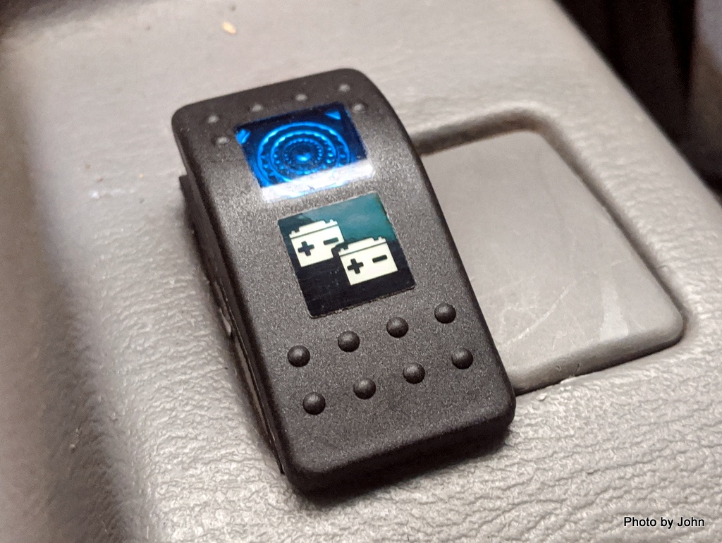
The charger can be turned on/off from a switch that fits into a blank spot on the console. Since I only use the battery on overnight trips, the charger is turned off for everyday use of the Subie.


With the car installation finished, I built a water (and sand) resistant box to house the battery and control panel.


It's one more thing that gets loaded in the canoe, but the system worked well and lets us do those extended float trips that we love. It's been a win-win solution.

Wednesday, October 28, 2020

Floating the Green River

This blog post is very different from my normal style. For my regular readers, feel free to ignore it. It’s my attempt to try to capture some helpful information about paddle powered trips on the flatwater sections of the Green River in Utah. 

The flatwater portion of the Green River is commonly included in lists of the best flatwater float trips in the United States and for good reason. Amazingly enough, most of these lists seem to think you should be in a hurry. It’s 120 miles from the town of Green River to the confluence and I’ve seen at least one magazine publisher that says you could do it in 3 days without providing any of the caveats.

If you’re going to do the Green, you have some choices to make. Spring, Summer, or Fall?Canoe, Kayak, SUP, or Raft? Labyrinth Canyon, Stillwater Canyon, or both? Green River State Park, Crystal Geyser, Ruby Ranch, or Mineral Bottom launch point? Solo, small group, or large group? Freeze dried or gourmet? How Fast? Obviously, personal preferences, finances, time availability, and skills are going to impact your choices.

Which Season?Lots of people do the Green in the spring because they like the faster currents that come with the higher water levels. You can check current or historic water levels at Green River and now also at Mineral Bottom. The downside of spring is fewer campsites since you’ll be limited to just high-water sites. Summer is HOT but many people do it then because that’s when they have vacation. Fall is my personal preference. Water levels are typically low and flow is slower but sandbar camps are plentiful and most of the bugs are gone.

Boat Choice? I started doing the Green 20 years ago. The first couple years, I used a large whitewater kayak because that’s what I had. For a couple years after that, I used wood strip sea kayaks because they had more space and speed, but since then I’ve used a solo or a tandem canoe since it’s much easier to haul the groover* in a canoe than a kayak. In the past couple years, we’ve seen an increasing number of stand-up paddleboards. Only once did we see a solo, self-supported SUP. Usually it’s a small group of SUPs with a canoe or two to help haul their gear. It’s not unusual to see rafts, but… if you see a raft on the Stillwater section, they are headed to the whitewater of Cataract Canyon and taking out near Hite on Lake Powell. *All feces must be hauled out using an approved toilet system in accordance with your river permit.

Which Section? John Wesley Powell named Labyrinth and Stillwater canyons during his explorations of the Green and Colorado rivers in the mid 1800’s. Labyrinth Canyon is the upper section and includes the famous Bow Knot bend. It is managed by the BLM and requires a free permit. Stillwater Canyon technically starts below Mineral Bottom, but the Mineral Bottom boat ramp is commonly used to differentiate between the two sections. The Stillwater Canyon section flows through Canyonlands National Park. The Park starts at approximately river mile 47 and requires a permit issued by the NPS. There’s no charge for the flatwater day use permit, but the flatwater overnight permit carries a $30 reservation fee plus $20 per person.

Mineral Bottom can be a zoo!
Which Launch Point? There are four launch points on the flatwater portion of the Green River.

  1. Green River State Park in Green River, Utah is 120 river miles from the confluence or 68 miles from Mineral Bottom. There is a small fee for launching here.
  2. Crystal Geyser is five miles below the state park on river left. It’s actually cold water that erupts a couple times a day. People launching here add about 18 miles to a Labyrinth trip but avoid the fees that Ruby Ranch charges. The vast majority of the river banks between Green River and Ruby are privately owned.
  3. Ruby Ranch is a historic private ranch down a long and bumpy road but it won’t be the only long and bumpy road you might see. They currently charge $10 per boat and $5 per person to launch here, but it’s the launch point closest to where the canyon starts to rise from the river. Since we enjoy the Green River for the canyons, this is our preferred place to launch if we’re doing the Labyrinth.
  4. Mineral Bottom is the take-out for people doing the Labyrinth Canyon section and the put-in for people just doing the Stillwater Canyon section. The years that we’ve done both sections it has been a mandatory stop since we’ve had people joining our group at that point. Mineral Bottom is reached by a long and bumpy road that also includes a very steep, narrow, switchback section that provides great views of a bit of the river.

Group Size - The first time I did a section of the Green there were just two of us using whitewater boats. The next year we invited anyone that wanted to go from the local paddling club and ended up with 10 on the trip. Typically we’ve had 4 to 6 on a trip which keeps it small enough to be able to fit into some smaller campsites. The Labyrinth permit is limited to 25 people. The Canyonlands permit is limited to 40 which seems totally insane to me, but then enjoying the quiet while watching the shadows on the cliffs is what draws me back nearly every year. Every year we do see solos on the river and I’ve thought about it at times but I’ve never had my “must invites” turn down a trip invitation.

Food Style - We’ve done gourmet including barbequed ribeye steaks at Anderson Bottom one year and fresh made cinnamon rolls at the confluence another year, but tend towards boxed or canned meals from the grocery store. Most trips will be seen hauling ice chests but we’ve always gone lighter and smaller since I’m lazy and don’t want to handle a bunch of extra stuff.

How Fast depends on you. We clearly choose to travel slower than most groups. I’ve seen lots of groups planning 20 mile days in the fall but we enjoy a slower pace. Our trip pace has slowed down over the years and we’ll plan in at least one weather day (or two or three) since we’ve discovered breaking down and setting up camp is work that really doesn’t have to happen every day. Camps that provide some shade and a view and a place to hike will get a layover day if possible. Our latest trip was the 52 mile Stillwater canyon section. We took 9 days (including the jetboat shuttle day) while most groups we saw on the river were doing it in 5 days or so, including the upstream shuttle.

Since camps are first come and sandbars change every year, you may need a plan B and plan C. Since we always do the trip in late September to early October, we tend to avoid highwater (ledge) camps since they’re more work to get the gear from the boats to the camp and back. Sandbars are typically our first choice for overnight stops but I’ll admit to having a short list of highwater camps that we love, especially if we have a spare weather day to spend.

While I approach this (as do most people) from a paddle powered perspective, it is possible to see an occasional outboard on a jon boat or a raft or the NPS J-rigs. For years, the towns of Green River and Moab sponsored the Friendship Cruise over Memorial Day weekend which involved power boats going down the Green to the confluence and then up the Colorado to the Potash boat ramp outside of Moab. The Friendship Cruise website hasn’t been updated in years so I don’t know the current status. 

I’ve done one or more sections of the Green 16 times in the past 20 years. Twice I’ve seen someone paddling upstream, once on the Green river and once on the Colorado. The guy on the Green (20 years ago) had paddled to the confluence and was working his way back to Mineral Bottom when we saw him. I have no idea how many days it took him!

Helpful Sources The Belknap's Waterproof Canyonlands River Guide seems to be the default, but I prefer the much larger RiverMaps Guide to the Colorado & Green Rivers in the Canyonlands of Utah & Colorado because of the much better maps. The National Geographic Trails Illustrated map #210 of Canyonlands is reasonably useful, but only for Mineral Bottom down. It will give you the big picture, but the scale leaves you wanting more detail. Kelsey’s River Guide to Canyonlands National Park and Vicinity has abominable maps but in some ways it's my favorite because of the excellent information about the human history in the canyons. For example, he tells about the construction of the Mineral Bottom (Horsethief trail) road, the loss of a D8 Caterpillar while ferrying across the river at the lower end of Woodruff Bottom, and points out spots where uranium adits and mines were located. (The four links in this paragraph all point to Amazon. I do NOT get any benefit from Amazon.)

Shuttles: There are several services that support Labyrinth Canyon. Some have equipment rental as well as shuttle service while others provide just shuttle of your personal vehicle. They can be located wtih a quick Google search. There are two permit holders for jet boat services from Spanish Bottom and the confluence back to Moab. The past couple of years, one of those operators has not operated in the fall low-water season. I’ve always used Tex’s Riverways for our Stillwater Canyon trips and can’t say enough good stuff about them. The jet boat back up the Colorado to Moab is the cherry to top off a wonderful Green River trip full of new memories.


Wednesday, October 21, 2020

Deadhorse Down

One of the joys of Deadhorse is that there is afternoon shade. After getting camp set up on the sand berm at the mouth of the wash we went off to explore. The high camp (another 10' higher and a slippery path) was huge but would have been lots of work to access.


We were planning a layover day specifically so that we could go hiking. In 2015, we'd hiked to Newspaper Rock from the lower Cabin Bottom campsite. This time, we wanted to try the route from the other direction. It involved finding a way up the dry fall from the north side of the perched meander not far up the canyon from camp.


Route finding skills were important, not only for working up through the dry falls but also keeping track of the place to start back down on our return. Once we were up on the mesa, the view was expansive in all directions and the river disappeared - at least for awhile.


I didn't think to try to recreate the picture from our 2015 trip, but this one, while tighter, was from the same location. (And, yes, BJ checked to confirm there were no petroglyphs where she was leaning.) All told, it was about 2 miles round trip from camp. 


When we got back down to the wash in the canyon, the others went back to camp while I walked up the canyon. I heard that it dead-ended in a dry fall, but I didn't get that far since I'd told them I would be back in camp within an hour. Next time...


On Saturday, October 3rd, we left Deadhorse to continue downstream. Our campanions did a great job of demonstrating the amount of effort required to navigate on this calm morning.


This is the first year that we've passed the mouth of Horse canyon and found no bugs. On the flip side, it was much splashier than any of us remembered. We weren't sure where we were going to end up but we knew we needed to "waste" some time.


The sandbar on the inside of the corner at river mile 11.7 became our home for the evening. It wasn't as nice as previous years and we needed to spread out to find level spots for our tents, but it did offer some afternoon shade. 


The next day we continued our drift downstream. We'd heard that there was a huge sandbar in the mouth of Water Canyon but it turned out to be on river left across from the canyon. Since it didn't have any shade, we gave it a pass and continued on, rapidly running out of river.


We thought of going to the confluence and taking a layover day there, but we'd heard that Upper Spanish was marginal this year, while both middle and lower involve very steep carries to high camps. Instead, we called a sandbar on the left at river mile 3 our home. 


The next morning, we didn't leave camp until 10 a.m. because we didn't want to arrive at the confluence until after the jet boat had done its pickups. That wait put the sun angle just right for yet another reflection picture, this time about river mile 2.


The sandbar on river right at the confluence was huge this year. We washed the boats, ate some lunch, and then headed across the expanse of sand with our chairs to sit in the shade of a large tree at the base of the hill.


It was a lazy morning for our last morning on the river for this trip, watching the sunlight start its way down the hill while the moon continued its travel towards the west.


Our chariot passed by, right on schedule, and then returned after picking up groups that had camped further down the Colorado. Our group of four and another group of two loaded here and we headed upstream with another fun Green River trip in the books.