September 25, 2015 -- We woke to another day of blue skies and light breezes. We'd planned for a layover day at Anderson Bottom if we got the high camp. We decided long ago that it was too much work to schlep the gear up the bank for just an overnight!
The plan for the day was to visit the slot canyon, explore the cattle trail to the top of the White Rim, and visit the petroglyphs before returning to the shade of camp for the very warm afternoon.
The blue sky was marked by a high flying jet showing us the way to the slot canyon. Not hard to find - just follow the slopes upward. I was surprised to see the wash was clean and heavily scoured. There had obviously been some extensive flows through the area this year.
I hardly recognized the mouth of the slot. The last time I'd visited, 15 years ago, the entrance was flat, with just one move over or under an chock stone near ground level. Now there's a 15' deep mud hole scoured out under the chock stone, about midway up the lower left picture. I cropped and enlarged to picture to show what I'd seen 15 years ago.

We decided that exploration of the short slot was not worth the mud bath that would be required. Instead, Alan conned us into posing for him.
As near as I could find out, the cattle trail was "improved" in the early 1950's so that cattle could be moved from the Green River road on top of the White Rim down to the feed available at Anderson Bottom. They must have had really agile cattle!
The views from the top of the White Rim were expansive. A very different view from that seen from the river. This was the view looking to the southwest. About midway to the bluffs, there is a 4WD road that runs from the town of Green River south to the Maze district of Canyonlands NP.
View to the east.
The rest of this year's crew.
Suzanne, BJ, Julene, Alan, and Kathy with our camp in the far background.
This is apparently what they do to bloggers.
Thanks to their position well out of reach, the petroglyph panel on the northeast corner of the rincon's frog remain in good condition.
Looking back up river from the petroglyphs towards our camp. Unknown Bottom is off the right edge of the photo.
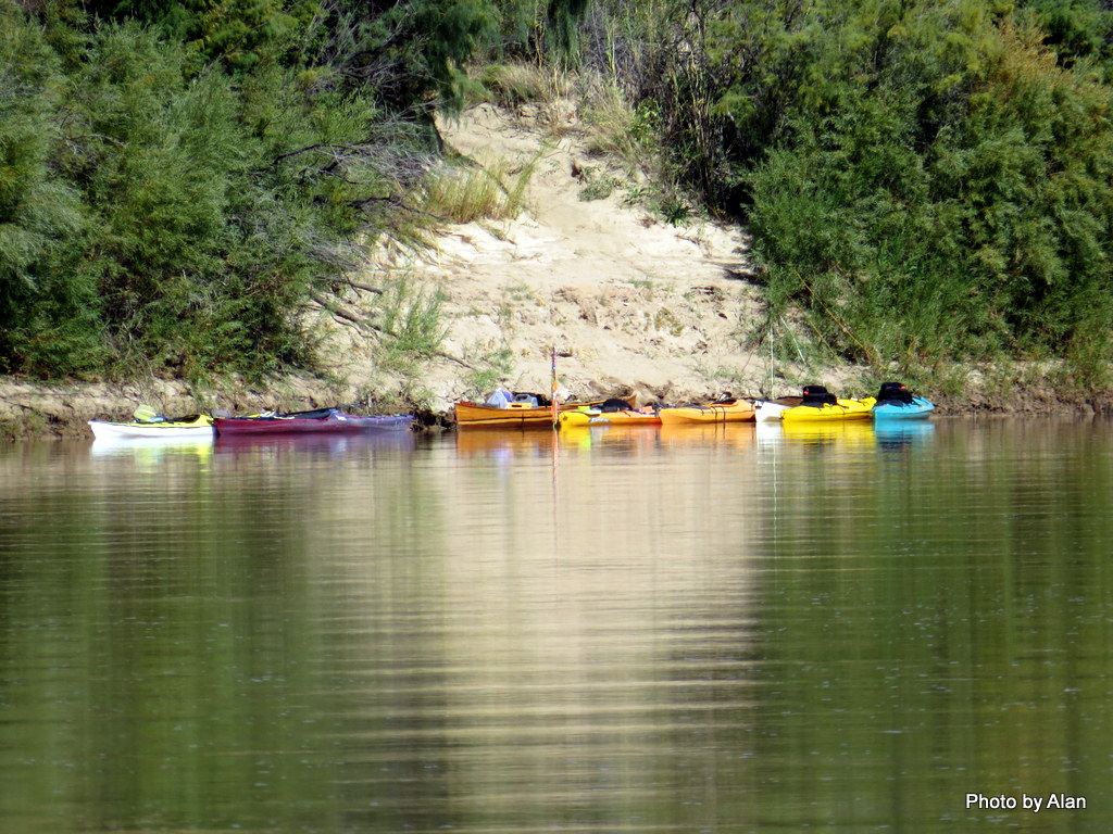
The rest of the group walked from the frog to Bonita Bend. Bonita was named by John Wesley Powell when he passed through this area, and is one of our favorite camps. BJ wanted to check it out with the hopes that it would be accessible for the trip she was planning with her gal friends. Alan got a great telephoto shot of our boats at the Anderson Bottom takeout, showing the slope that has to be navigated with all the gear.
Ascot came to visit again. There were two Western Screech Owls in the area, but this one was especially interested in Kathy's attempts to talk owl. It made for an interesting evening in camp.


I did the 95 mile section in 11 days some 15-20 years ago and simply loved that float... thanks for letting me relive that wonderful experience
ReplyDeleteLast year we did the 97 miles from Ruby Ranch to the confluence. We so enjoyed the two storm driven layover days at Bowknot Bend that we decided to incorporate extra days in this year's Stillwater trip. Might have worked but too hot this year for midday hiking and shade started driving our camp decisions. Last year's trip is on the blog starting in the early October posts.
DeleteI went with a group that did the trip annually, I like the idea of the jet boat back because we night hiked about 6 miles back to a truck we left at a campsite in the Canyonlands NP
DeleteHow'd you get your boats out?
DeleteWe had rafts and we simply buried them along with all the heavy gear. He would go several times a year and on the last run he would ferry the boats out like you did.
Delete