Friday, October 17, 2014

Day Eleven - Green River

Sunday, October 5 - We left our last Green River camp on the Mile 8 sandbar about 10 a.m., doing everything we could to drag out the last paddling day of the trip.

Ian's 15' Coleman canoe was the slowest boat of the group so we put him in the lead, allowing the rest of us to spend more time watching the cliffs continue their change as we moved downstream.

It was a bit surprising to not see any boats around the mouth of Water and Shot canyons. Often times, it is a relatively busy location.

There was a multi terraced sandbar in the Mile 3 corner that became a spot to stop for a snack. The low edge on the upstream side had a layer of slippery mud, but the higher downstream portion was dry.

The area around river mile 2 is a favorite because it is often glassy calm with great reflections. Just around the corner in the distance on river right is Powell Canyon. It is supposed to have a high water camp, but I've never found a kayak friendly landing area.

When we see the turtle (left) and iguana (right) on top of the cliffs, we know we're almost out of river. The cliffs that support these markers are on the left side of the Colorado river which flows from left to right at the confluence.


About two miles down the Colorado from the confluence with the Green, we spotted the warning sign which also serves as the point to sign up for campsites along Spanish Bottom.

I landed near the sign to see what sites might be available and to sign up for one. I was surprised to see that the previous user had left the lid open on the register box but since it didn't rain last night it wasn't a big deal.

Meanwhile, the group decided that the steep sand bank just upstream would be adequate and that there was no reason to continue further downstream. We were able to create some flat tent pads and erected our tents and then got started cleaning our boats.

John West took a picture of the rest of the group once we got the boats cleaned, stacked on tarps, and tied off in preparation for tomorrow's jet boat shuttle up the Colorado river. It was important to get the boats clean so that we didn't have dirt and sand blowing from the boats on the upstream trip.

Once again, Beth fixed a massive meal that fed six of us. This time it was based on tortilla soup with a bunch of other things added to the pot. The end result was excellent!

We traveled about 10 river miles with the Green flowing about 5000 cfs today. We didn't see any other boats during our time on the water. The other shuttle company headed downstream while we were cleaning our boats and returned an hour later with a group of 10 who had stayed at Lower Red Lake the previous evening as well as the kayaks we'd seen the previous couple days.

About 4 p.m., a group of three canoes and an inflatable kayak arrived to sign in. They continued downstream to stay at the Upper Spanish Bottom site and will be on our shuttle tomorrow.

The weather continued clean, calm, and warm all day.

Thursday, October 16, 2014

Day Ten - Green River

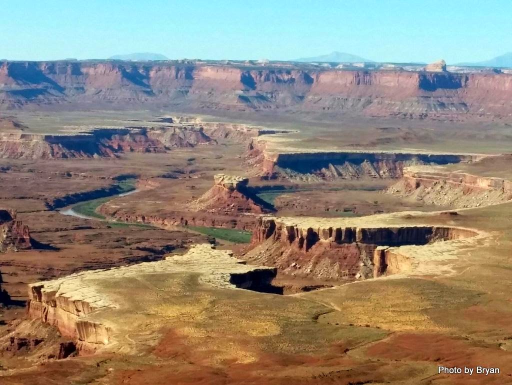
Saturday, October 4 - We were on the water from our sandbar camp at the north end of Turks Head by 9:30 a.m. Our campsite isn't visible in this photo from one of Canyonland's viewpoints - it's hidden by the mesa in the right center of the picture.

There were six canoes at the high water camp on river right just below Turk's Head when we passed by. Each pair was rigged together as a catamaran that Tex's calls a T-Cat. The stability makes it especially ease to unload the rig onto the ledges at this camp.

It looked like the high site at Dead Horse was accessible this year as well as space for a couple tents on the upstream side at the mouth of the wash. This one seems to change every year.

By the time we got to river mile 19, John was getting into his "kick back and enjoy life" position. The olive drum in his tank well made a brace for lounging.

Ian used a kayak paddle with his 15' canoe which he paddled solo. Beth's Caper sported gossamer wings for the last portion of the trip. They had other functions at night.

 It was another great day for reflections. Not a cloud in the sky!

We stopped at the island sandbar near the mile 15 corner. It's almost always there, but often in poor condition. I expected to find just mud but was surprised to find a high buildup of sand, perhaps because of the large amount of branches buried at the head of the island. If you look closely you'll see that not everyone got out of their boats to stretch.

As usual, the edge of this island was really muddy! The price to pay for a stretch break was trying to minimize the amount of mud taken on board when we got back in the boats.

John had a government biologist friend who told him there weren't any bugs on the river. Not so! We dealt with some mosquitoes at a few locations, and had bug hatches on several short sections of the river. The section at Horse Canyon was the worst. We just tried to hold our breath until we got through it.

I tried to cheat a line about mile 11 and ended up walking for 50 feet or so. The joys of the very silty water is that you have to pay close attention to clues as to the channel's location. I thought I was going to have enough depth to slip past - I did, once I got out of the boat!

Some of the group were having great fun identifying rock formations such as the monkey's head at the top of the cliff.

We spotted the group of kayaks from the day before as we approached Jasper Canyon. They appeared to be stopping to view the famous dwelling hiding under the ledge so we elected to continue on.

At the last minute, they also continued on, apparently in a "race" for campsites, except that they didn't paddle much. In chatting with one of them, we discovered that they were interested in a camp several miles beyond where we were hoping to go. They did give us a bit of a chuckle as we observed their deck loads. One gal could hardly see over the stuff tied to her front deck.

We declared the remains of the sandbar inside the mile 8 corner to be our home for the night. Lots of height, and dry, but not an excess of level space for the tents.


John was able to catch the moon as it rose above the bluff.

We hauled a fire pan for the whole trip - it's required by the National Park Service. We also hauled a dry bag for the second half of the trip that was full of off-cuts of the cedar strips we'd used to build Kathy's kayak deck. Assuming we might be sharing a campsite the next night, we used the wood for a small fire while we shared our trip experiences.

We traveled approximately 14.5 river miles today on a flow of 5000 cfs. It was another day of blue skies and occasional light breezes.

We saw the six canoes below Turks Head who had another week before their shuttle, the four kayaks who were headed to Shot Canyon and then out to catch their shuttle on Sunday, and two other kayaks who weren't due to come off the river until Wednesday but were very unhappy with the mud and hoped to go home early. Meanwhile, we were wishing we could stretch out the trip even further.

Wednesday, October 15, 2014

Day Nine - Green River

Friday, October 3 - Departure from Bonita Bend went very smoothly. The water level was down around 9" from yesterday's high point but still plenty of depth to paddle out to the mouth of the wash. We were able to load each of the boats on dry land and then lift/slide them into the water, with just one volunteer (Alan) wading in the knee deep water to assist with the launchings.

Morning travel northeast along Unknown Bottom is always one of my favorites. The cliffs on river right cast a large shadow and seem to enhance the reflections along this reach of the river.

As we approach the start of Valentine Bottom, anticipation increases as we start looking for the first sign of granary ruins on river left.

The first ruin I spotted wasn't in very good shape but was clearly the remains of a built structure. All of the structures are located in the same interface at the bottom of the White Rim sandstone layer.

A couple more. But I was really looking for my favorite (because it was the first I ever spotted on the Green.)

The square corner gives it away. It's located right in the middle of this picture. It's on river left about river mile 28.6 or so. I'm basing the river mile estimates on Belknap's Revised Canyonlands River Guide, copyright 1996. I don't know if there are any changes to the mileage in the new, much improved color edition.

I've never been able to figure out how they got up to this location to build the structure. It appears the back wall is missing as is any roof structure. I wonder if the structure was ever completed?

A bit further downstream was this series of three smaller structures. I thought they were a bit unusual because they were much more exposed to weather.

As we continued downstream, it was interesting to note the the massive sandbar from two years at mile 28 was now entirely gone except for the tamarack covered portion. There were some habitable locations on the island about river mile 27.

We stopped on river left about river mile 25.8 to view the "guard tower" built into the cliff on river right at that point. While the top of the sandbar was dry, the edges were very muddy!

Hitting the jackpot once again, we found an adequate sandbar at the northwest corner of Turks Head. The river bottom was firm but the sandbar edge was covered with a couple inches of very slippery mud. Teamwork reduced the slippage and kept the top of the sandbar free of tracked in mud.

Once our camp was set up, most of us decided to see if we could bushwhack a route through the tammies. Of course, this year the sandbar was located closer to the corner where the band of tammies is the thickest. We ended up flagging our route with six bandannas so that we could retrace our steps.

The view of Soda Springs Canyon from the Turks Head bench is a favorite, contrasting with the deep blue sky. This year we decided it was a chipmunk sitting on top of the cliff at the left.

The brothers West enjoying the view and thinking about the peoples that lived here a thousand years ago. Craig Childs' House of Rain suggests that this area of the Green River was the northern limits of the Ancient Pueblo peoples.

We launched from Bonita Bend about 9:30 a.m. and spent three hours traveling about 8.5 river miles. The river was flowing about 6000 cfs and dropping. We passed three or four kayaks that were just breaking camp at the cabin site (river mile 25.3) about 11:30 a.m. They passed us as we were setting up camp. We didn't see anyone else throughout the day.