Sunday, April 19, 2015

Betatakin

Suzy, our Garmin GPS, wanted to lead me astray, but I’d already done some homework on the location of the Navajo National Monument. I knew that I needed to turn on Arizona 564, right after passing the coal loading silos from the infamous Black Mesa mine. Black Mesa is the source of coal for the power plant in Page that creates the smog that blankets the Grand Canyon.

It’s 9 miles up the road to the Monument. Beautiful country, but it comes with a couple caveats. There is a length limit because of turn around space at the end of the road. The sign near the highway says no trailers over 28 feet. Total length limit is 40 feet with any single unit limited to 28 feet.

As you get to the top of the hill, you may or may not see the small warning sign. They don’t use speed bumps.

Rather, they use concrete gutters that will rattle your teeth unless you cross them at a crawl. There are several, and not all of them are signed. Since they are formed of concrete so they’re different than the pavement IF you’re paying attention. Don’t ask me how I know…

Once you get there, if you try to get to the Canyon View Campground, you’ll find this road. It’s the 10 miles of unpaved road from Shonto that Suzy thought would be a good idea for me.

The monument (and the Navajo Nation) observe Daylight Saving time unlike the rest of Arizona. As a result, I got here after the Visitor Center closed but the sunlight and the cliffs were begging me to come take a look. The Monument is home to two major cliff dwellings. Betatakin is visible from an overlook or accessed on a ranger led, 5 mile r/t hike. Keet Seel is the largest known cliff dwelling in Arizona, and is accessed via a 17 mile overnight hike. Both in-canyon hikes require permits.

The overlook trail was about 2 miles r/t from my spot in the campground. It was going to be difficult to get lost since this trail was paved from the Visitor Center to the overlook.

The Betatakin cliff dwelling view point is across the canyon. The ranger led hike drops 700 ft into the canyon to access the dwellings. By the time I arrived, the settlement was in shadows.

There are quite a few reasonable intact rooms stage right including a few with wood rafters. The structures on stage left didn’t seem to fare as well with a few shorter walls and foundations remaining.

There is lots of bare slickrock in the area with trees showing lots of character as they struggle to survive.

and a few clumps of color that caught my eye. No idea what kind of plant it is, but I appreciated the color that it added.


I stayed at the Sunset View campground where it got down to 38 degrees thanks to the 7200 ft elevation. A beautiful place that was only about 25% full.

This post uploaded and scheduled thanks to the fast wifi with dinner at Twin Rocks Cafe in Bluff, Utah.

Friday, April 17, 2015

She Was Right!

A blogger / philosopher that I follow recently said something about chronological order not being all that important – or something like that. In any case, this one is out of sequence.

Perhaps this should go under the category of “confession is good for the soul.”


She said, “Why do you want to go, it’s going to be cold.” I said, “It will be wonderful hiking temperatures.” Even though we definitely have different temperature preferences, she was more right than I was, at least for a couple days!  

While I was eating dinner and uploading blog posts at Twin Rocks in Bluff on Tuesday evening, I overheard a couple behind me who were busy trying to find a place to store their RV because it was going to be so cold that they were going to fly home and come back later to finish their trip.

I checked the weather report in Blanding on Wednesday morning, and it was showing that it was expected to get down to 24 degrees Wednesday night and then into the mid 50’s on Thursday before slowly returning to the mid 70’s (and up) weather I’d been experiencing.

I’m here to report that it DID get down to 24 degrees Thursday morning at Comb Wash, and it took the furnace over 30 minutes to get the Scamp up to the mid 50’s from an initial inside temp of 28 degrees, but I still went hiking. I’d read somewhere that the National Lands Pass would suffice for the fee that is charged for a number of the highly popular Cedar Mesa hikes. According to the sign near the South Fork of Mule Canyon, not so. My $5 donation was a small price to pay for a 7 day permit. I was the first one on the trail, leaving at 9 a.m.

Various publications indicated the hiker created trail was obvious. I’d agree! It wandered back and forth across the mostly dry drainage, but was always obvious.

My initial point of interest for the hike was a very well-known group of structures. I was there a little early for the best light and it was definitely too cold to sit around waiting for the sun to move, although the thermometer when I left the trailer said it was up to 34 degrees.

Since it has been reported that there are at least nine ruins in this drainage, I continued up the wash, looking for the next one and watching the clouds build. I thought I had a pretty good understanding of where it should be, but spent quite a bit of time stirring around in a little side box canyon without success.

All I found in that area was a little bit of color and a lot of interesting country.

When the sky darkened more and started snowing, the camera went in the pack as I headed back down the canyon. It wasn’t snowing hard, yet, and the spider webs on the cactus were catching flakes. I’d told myself when I left that I’d turn around at noon, but I didn’t count on the very cold wind and the snow.

I stopped by House on Fire for a couple more quick pictures on the way out. If you get the light just right, the rock above the structure looks like flames, thus the name. I was back to the truck by 11:45 local time.

I wish I’d brought my thick, fuzzy, fleece pants to wear in the trailer. I was afraid if I turned the heater on in the trailer at 3 p.m. that I’ll hear her say, “I told you so.” Sure glad I brought both poncho liners!

A big thanks to Jon Vermilye who used a much better picture of House on Fire to decorate the refrigerator door in his Escape. It was that picture that was the initial impetus for this exploratory trip.

I woke up this morning to rain that turned to snow and low visibility at my Comb Wash camp. Looked like a good day to go to town instead of the several site visits I had planned.  

This post was published in real time thanks to the Blanding Visitor Center on my 2nd visit!

Tuesday, April 14, 2015

Wupatki National Monument

Wupatki National Monument is located east of Highway 89, north of Flagstaff. The Visitor Center is just nearly midway on the 35 mile paved loop road that connects Wupatki and Sunset Crater National Monuments to Highway 89. I entered at the Sunset Crater end which meant much of the loop road was a descent for me. Part of the road crosses National Forest land. At least one spot near mile marker 12 looked like boondocking potential if the Forest Service hasn’t put it off limits.

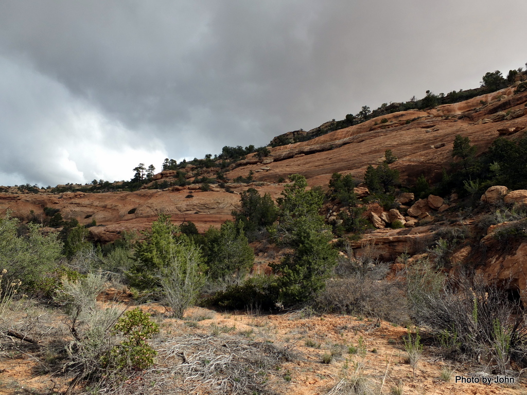
There are unmarked ruins scattered throughout the Monument, sometimes near the road. The major ruins are clearly marked.

The Wukoki Pueblo remains were visible from nearly a mile away in spite of the blowing dust. The majority of the ruins in this area were freestanding masonry, in this case built on a rock. There’s a parking lot near the ruin, with a few spaces for RV parking. When I was there Sunday afternoon, I was the third vehicle in the lot.

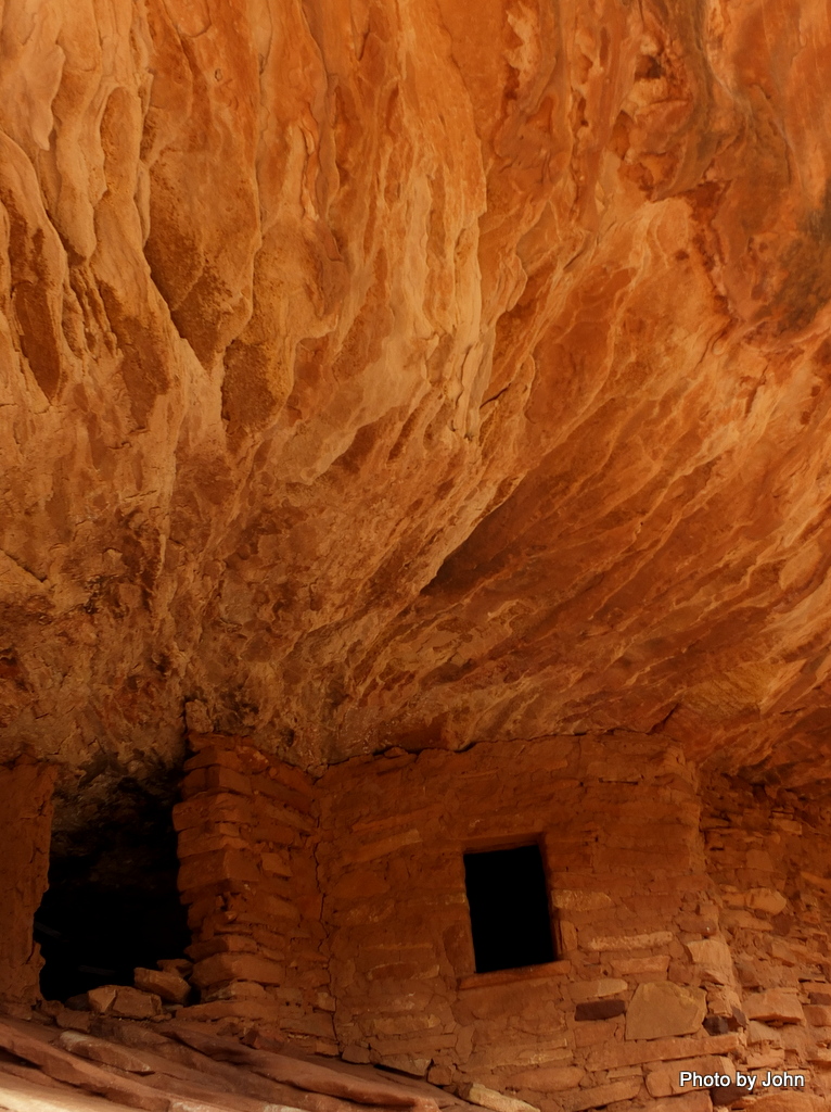
This ruin, along with the others that I visiting here, have seen significant stabilization and reconstruction. I couldn’t find any available staff to ask about when the rebuilding was done, but there is lots of visible cement mortar in places.

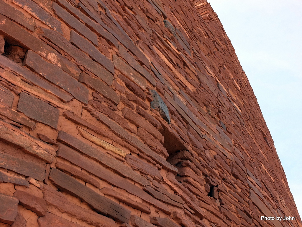
I loved looking up this wall.

If you looked close, you could find finger prints in the clay.

The Wupatki ruin was larger and included multiple structures. It also included a lot more people and a lot more cars in the lot.

I was really impressed with this rock that was built into the wall, but as I looked closer, you could see lines where repair work had been done below the rock, including the wood post that had been trimmed with a chainsaw.

As I pulled in to the Citadel Pueblo parking lot I spotted this ruin and that – not much. Must have been what others thought as I watched a couple cars slow down and then keep going.

But if you looked up, you could see that the whole top of the hill was a built up masonry wall

on top of the lava rock that formed the original hill.

From the Citadel, you were supposed to be able to spot eight other Pueblos. I spotted four, including this one.


From here, I’m continuing northbound, bucking a very stiff quartering headwind, looking for cliff dwellings. I'm also looking for free wifi since I left our mifi home with BJ.

This post was uploaded and scheduled complements of the wifi (and coffee) at McDonald's in Kayenta, Az.